You are here: Home > Network List > TA - USArray Transportable Network (new EarthScope stations) Stations List
> Station F21K Alatna River, AK, USA > Earthquake Result Viewer
F21K Alatna River, AK, USA - Earthquake Result Viewer
| Earthquake location: |
Turkey |
| Earthquake latitude/longitude: |
37.9/29.7 |
| Earthquake time(UTC): |
2019/08/08 (220) 11:25:31 GMT |
| Earthquake Depth: |
10 km |
| Earthquake Magnitude: |
5.8 Mww |
| Earthquake Catalog/Contributor: |
NEIC PDE/us |
|
| Network: |
TA USArray Transportable Network (new EarthScope stations) |
| Station: |
F21K Alatna River, AK, USA |
| Lat/Lon: |
67.22 N/153.48 W |
| Elevation: |
597 m |
|
| Distance: |
75.1 deg |
| Az: |
1.281 deg |
| Baz: |
357.399 deg |
| Ray Param: |
0.05187547 |
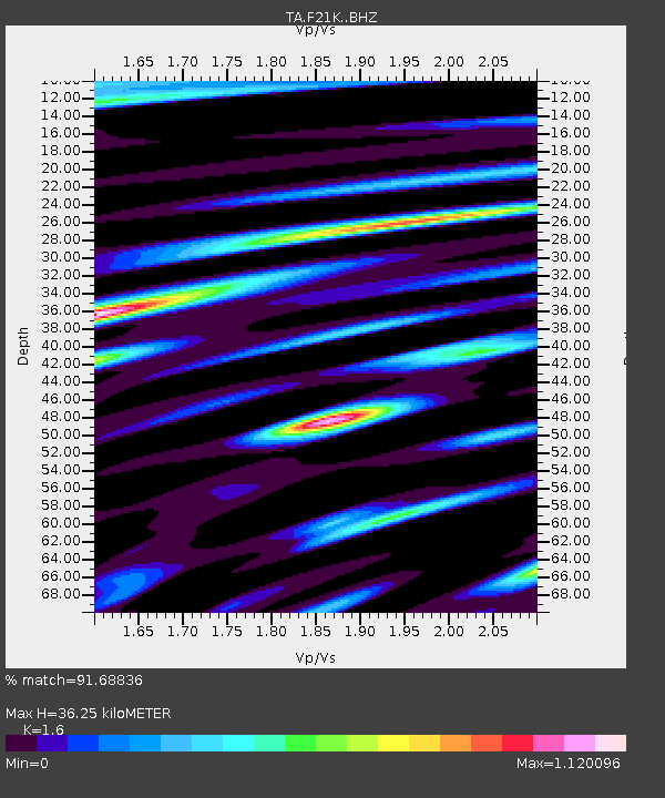
| Estimated Moho Depth: |
36.25 km |
| Estimated Crust Vp/Vs: |
1.60 |
| Assumed Crust Vp: |
6.455 km/s |
| Estimated Crust Vs: |
4.035 km/s |
| Estimated Crust Poisson's Ratio: |
0.18 |
|
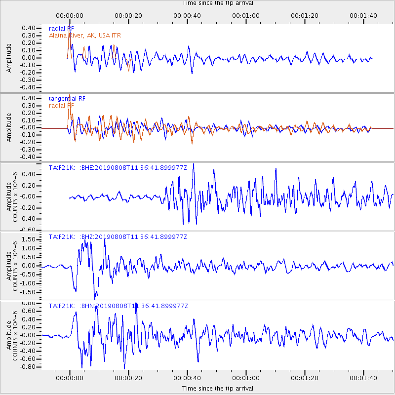
| Radial Match: |
91.68836 % |
| Radial Bump: |
400 |
| Transverse Match: |
85.320335 % |
| Transverse Bump: |
400 |
| SOD ConfigId: |
19053131 |
| Insert Time: |
2019-08-22 11:36:57.199 +0000 |
| GWidth: |
2.5 |
| Max Bumps: |
400 |
| Tol: |
0.001 |
|
Signal To Noise
| Channel | StoN | STA | LTA |
| TA:F21K: :BHZ:20190808T11:36:41.899977Z | 20.099165 | 7.852539E-7 | 3.9068983E-8 |
| TA:F21K: :BHN:20190808T11:36:41.899977Z | 12.667474 | 3.6958204E-7 | 2.9175672E-8 |
| TA:F21K: :BHE:20190808T11:36:41.899977Z | 3.0166633 | 1.06332486E-7 | 3.5248377E-8 |
| Arrivals |
| Ps | 3.5 SECOND |
| PpPs | 14 SECOND |
| PsPs/PpSs | 18 SECOND |


