You are here: Home > Network List > TA - USArray Transportable Network (new EarthScope stations) Stations List
> Station J16K Anvik River, AK, USA > Earthquake Result Viewer
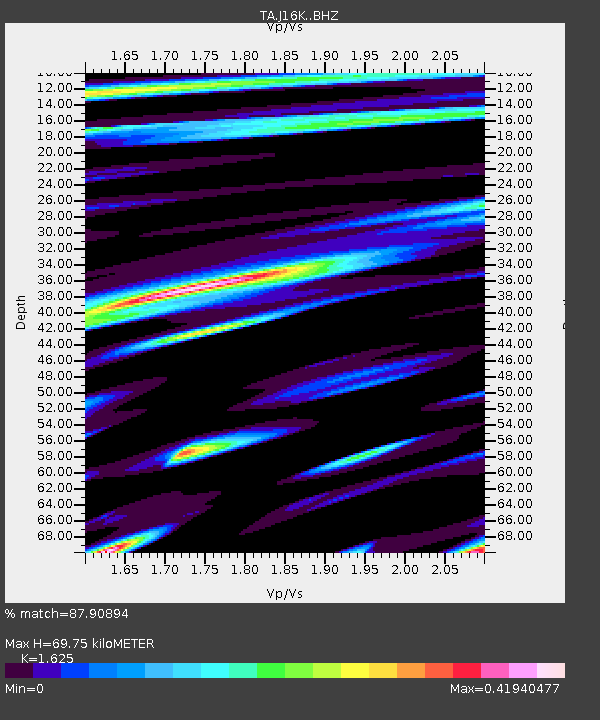
J16K Anvik River, AK, USA - Earthquake Result Viewer
| Earthquake location: |
Turkey |
| Earthquake latitude/longitude: |
37.9/29.7 |
| Earthquake time(UTC): |
2019/08/08 (220) 11:25:31 GMT |
| Earthquake Depth: |
10 km |
| Earthquake Magnitude: |
5.8 Mww |
| Earthquake Catalog/Contributor: |
NEIC PDE/us |
|
| Network: |
TA USArray Transportable Network (new EarthScope stations) |
| Station: |
J16K Anvik River, AK, USA |
| Lat/Lon: |
63.28 N/160.60 W |
| Elevation: |
328 m |
|
| Distance: |
78.8 deg |
| Az: |
4.726 deg |
| Baz: |
351.715 deg |
| Ray Param: |
0.0494142 |
| Estimated Moho Depth: |
69.75 km |
| Estimated Crust Vp/Vs: |
1.62 |
| Assumed Crust Vp: |
6.276 km/s |
| Estimated Crust Vs: |
3.862 km/s |
| Estimated Crust Poisson's Ratio: |
0.20 |
|
| Radial Match: |
87.90894 % |
| Radial Bump: |
400 |
| Transverse Match: |
62.963825 % |
| Transverse Bump: |
400 |
| SOD ConfigId: |
19053131 |
| Insert Time: |
2019-08-22 11:37:21.324 +0000 |
| GWidth: |
2.5 |
| Max Bumps: |
400 |
| Tol: |
0.001 |
|

Signal To Noise
| Channel | StoN | STA | LTA |
| TA:J16K: :BHZ:20190808T11:37:02.375013Z | 11.686709 | 6.963365E-7 | 5.9583623E-8 |
| TA:J16K: :BHN:20190808T11:37:02.375013Z | 5.62205 | 2.7652604E-7 | 4.9185978E-8 |
| TA:J16K: :BHE:20190808T11:37:02.375013Z | 1.6840208 | 9.241454E-8 | 5.4877315E-8 |
| Arrivals |
| Ps | 7.2 SECOND |
| PpPs | 28 SECOND |
| PsPs/PpSs | 35 SECOND |


