You are here: Home > Network List > TA - USArray Transportable Network (new EarthScope stations) Stations List
> Station M15K Kasigluk River, AK, USA > Earthquake Result Viewer
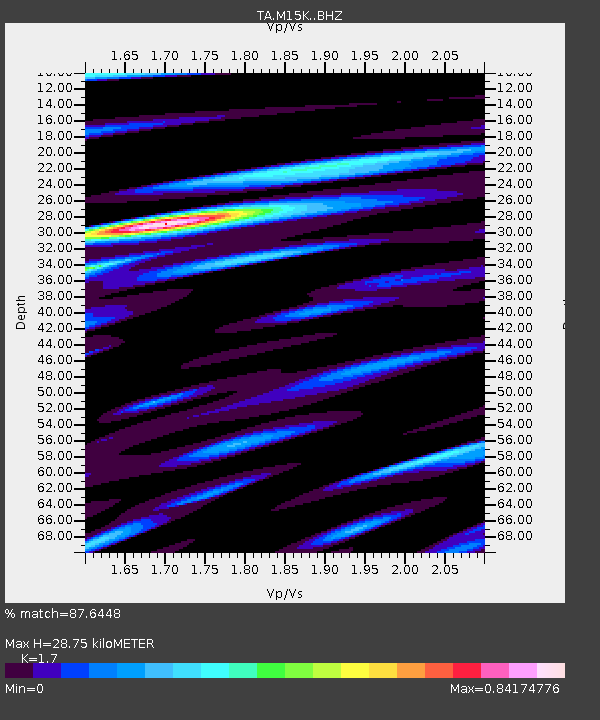
M15K Kasigluk River, AK, USA - Earthquake Result Viewer
| Earthquake location: |
Turkey |
| Earthquake latitude/longitude: |
37.9/29.7 |
| Earthquake time(UTC): |
2019/08/08 (220) 11:25:31 GMT |
| Earthquake Depth: |
10 km |
| Earthquake Magnitude: |
5.8 Mww |
| Earthquake Catalog/Contributor: |
NEIC PDE/us |
|
| Network: |
TA USArray Transportable Network (new EarthScope stations) |
| Station: |
M15K Kasigluk River, AK, USA |
| Lat/Lon: |
60.69 N/160.69 W |
| Elevation: |
210 m |
|
| Distance: |
81.3 deg |
| Az: |
5.147 deg |
| Baz: |
351.712 deg |
| Ray Param: |
0.047656037 |
| Estimated Moho Depth: |
28.75 km |
| Estimated Crust Vp/Vs: |
1.70 |
| Assumed Crust Vp: |
6.182 km/s |
| Estimated Crust Vs: |
3.637 km/s |
| Estimated Crust Poisson's Ratio: |
0.24 |
|
| Radial Match: |
87.6448 % |
| Radial Bump: |
400 |
| Transverse Match: |
81.598976 % |
| Transverse Bump: |
400 |
| SOD ConfigId: |
19053131 |
| Insert Time: |
2019-08-22 11:37:37.544 +0000 |
| GWidth: |
2.5 |
| Max Bumps: |
400 |
| Tol: |
0.001 |
|

Signal To Noise
| Channel | StoN | STA | LTA |
| TA:M15K: :BHZ:20190808T11:37:16.200025Z | 11.010344 | 7.218786E-7 | 6.556368E-8 |
| TA:M15K: :BHN:20190808T11:37:16.200025Z | 6.595354 | 3.0826777E-7 | 4.674014E-8 |
| TA:M15K: :BHE:20190808T11:37:16.200025Z | 1.4616019 | 8.560537E-8 | 5.8569558E-8 |
| Arrivals |
| Ps | 3.3 SECOND |
| PpPs | 12 SECOND |
| PsPs/PpSs | 16 SECOND |


