You are here: Home > Network List > TA - USArray Transportable Network (new EarthScope stations) Stations List
> Station M26K Nabesna, AK, USA > Earthquake Result Viewer
M26K Nabesna, AK, USA - Earthquake Result Viewer
| Earthquake location: |
Turkey |
| Earthquake latitude/longitude: |
37.9/29.7 |
| Earthquake time(UTC): |
2019/08/08 (220) 11:25:31 GMT |
| Earthquake Depth: |
10 km |
| Earthquake Magnitude: |
5.8 Mww |
| Earthquake Catalog/Contributor: |
NEIC PDE/us |
|
| Network: |
TA USArray Transportable Network (new EarthScope stations) |
| Station: |
M26K Nabesna, AK, USA |
| Lat/Lon: |
62.40 N/143.00 W |
| Elevation: |
888 m |
|
| Distance: |
79.8 deg |
| Az: |
356.55 deg |
| Baz: |
5.863 deg |
| Ray Param: |
0.04869801 |
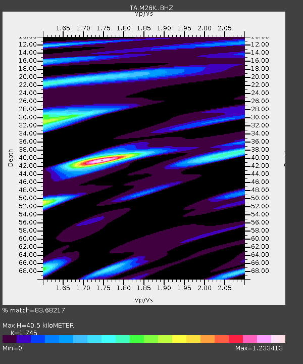
| Estimated Moho Depth: |
40.5 km |
| Estimated Crust Vp/Vs: |
1.75 |
| Assumed Crust Vp: |
6.566 km/s |
| Estimated Crust Vs: |
3.763 km/s |
| Estimated Crust Poisson's Ratio: |
0.26 |
|
| Radial Match: |
83.68217 % |
| Radial Bump: |
400 |
| Transverse Match: |
87.79004 % |
| Transverse Bump: |
400 |
| SOD ConfigId: |
19053131 |
| Insert Time: |
2019-08-22 11:37:42.041 +0000 |
| GWidth: |
2.5 |
| Max Bumps: |
400 |
| Tol: |
0.001 |
|

Signal To Noise
| Channel | StoN | STA | LTA |
| TA:M26K: :BHZ:20190808T11:37:08.075025Z | 15.14063 | 6.9092465E-7 | 4.563381E-8 |
| TA:M26K: :BHN:20190808T11:37:08.075025Z | 3.0814679 | 1.6267842E-7 | 5.2792508E-8 |
| TA:M26K: :BHE:20190808T11:37:08.075025Z | 3.1136827 | 1.18646206E-7 | 3.8104783E-8 |
| Arrivals |
| Ps | 4.7 SECOND |
| PpPs | 16 SECOND |
| PsPs/PpSs | 21 SECOND |


