You are here: Home > Network List > IU - Global Seismograph Network (GSN - IRIS/USGS) Stations List
> Station PMG Port Moresby, New Guinea > Earthquake Result Viewer
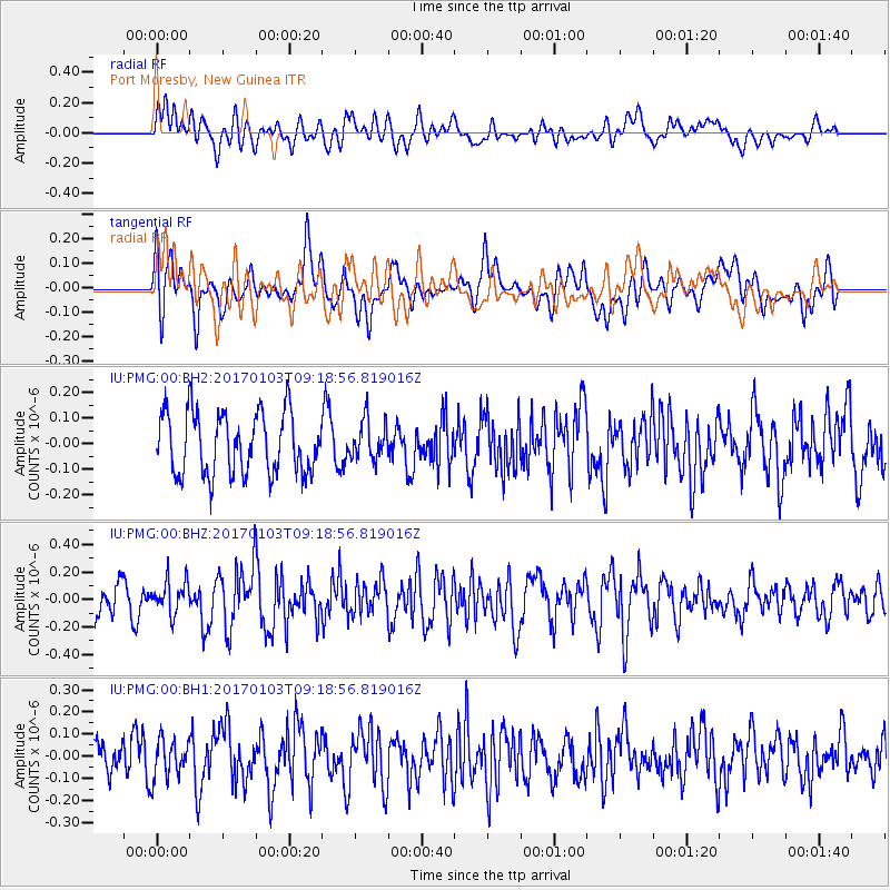
PMG Port Moresby, New Guinea - Earthquake Result Viewer
*The percent match for this event was below the threshold and hence no stack was calculated.
| Earthquake location: |
India-Bangladesh Border Region |
| Earthquake latitude/longitude: |
24.0/92.0 |
| Earthquake time(UTC): |
2017/01/03 (003) 09:09:02 GMT |
| Earthquake Depth: |
36 km |
| Earthquake Magnitude: |
5.5 mb |
| Earthquake Catalog/Contributor: |
NEIC PDE/us |
|
| Network: |
IU Global Seismograph Network (GSN - IRIS/USGS) |
| Station: |
PMG Port Moresby, New Guinea |
| Lat/Lon: |
9.40 S/147.16 E |
| Elevation: |
90 m |
|
| Distance: |
63.3 deg |
| Az: |
114.943 deg |
| Baz: |
302.828 deg |
| Ray Param: |
$rayparam |
*The percent match for this event was below the threshold and hence was not used in the summary stack. |
|
| Radial Match: |
54.05217 % |
| Radial Bump: |
400 |
| Transverse Match: |
53.854206 % |
| Transverse Bump: |
400 |
| SOD ConfigId: |
1943534 |
| Insert Time: |
2017-01-17 09:10:18.548 +0000 |
| GWidth: |
2.5 |
| Max Bumps: |
400 |
| Tol: |
0.001 |
|
Signal To Noise
| Channel | StoN | STA | LTA |
| IU:PMG:00:BHZ:20170103T09:18:56.819016Z | 1.0225831 | 1.2019372E-7 | 1.17539315E-7 |
| IU:PMG:00:BH1:20170103T09:18:56.819016Z | 0.97966266 | 8.636095E-8 | 8.815376E-8 |
| IU:PMG:00:BH2:20170103T09:18:56.819016Z | 0.64125437 | 7.635067E-8 | 1.19064566E-7 |
| Arrivals |
| Ps | |
| PpPs | |
| PsPs/PpSs | |


