You are here: Home > Network List > TA - USArray Transportable Network (new EarthScope stations) Stations List
> Station E11A Bogner Ranch, Nez Perce, ID, USA > Earthquake Result Viewer
E11A Bogner Ranch, Nez Perce, ID, USA - Earthquake Result Viewer
| Earthquake location: |
South Of Fiji Islands |
| Earthquake latitude/longitude: |
-26.0/-177.5 |
| Earthquake time(UTC): |
2007/12/09 (343) 07:28:20 GMT |
| Earthquake Depth: |
152 km |
| Earthquake Magnitude: |
7.0 MB, 7.8 MW, 7.7 MW |
| Earthquake Catalog/Contributor: |
WHDF/NEIC |
|
| Network: |
TA USArray Transportable Network (new EarthScope stations) |
| Station: |
E11A Bogner Ranch, Nez Perce, ID, USA |
| Lat/Lon: |
46.36 N/116.21 W |
| Elevation: |
831 m |
|
| Distance: |
90.9 deg |
| Az: |
37.417 deg |
| Baz: |
232.143 deg |
| Ray Param: |
0.041610647 |
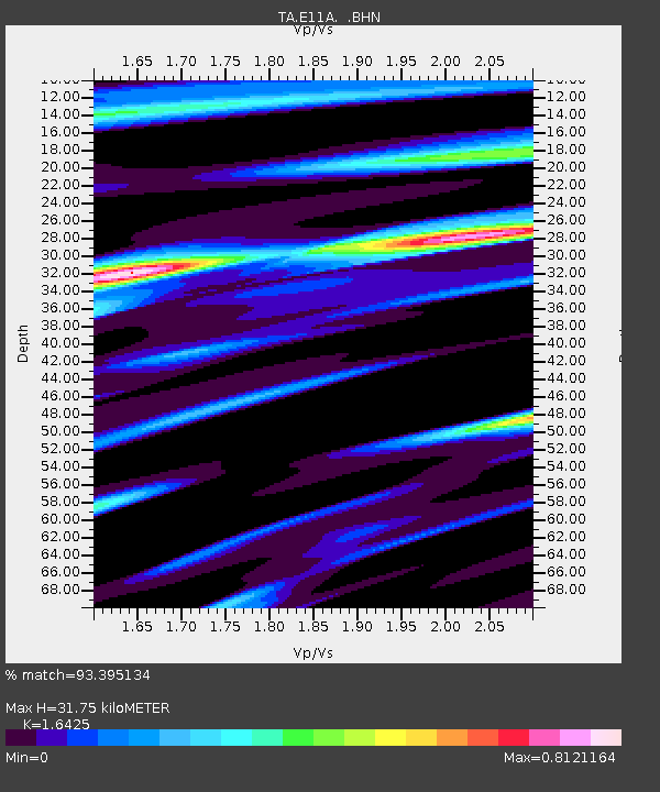
| Estimated Moho Depth: |
31.75 km |
| Estimated Crust Vp/Vs: |
1.64 |
| Assumed Crust Vp: |
6.571 km/s |
| Estimated Crust Vs: |
4.0 km/s |
| Estimated Crust Poisson's Ratio: |
0.21 |
|
| Radial Match: |
93.395134 % |
| Radial Bump: |
400 |
| Transverse Match: |
87.32489 % |
| Transverse Bump: |
400 |
| SOD ConfigId: |
2564 |
| Insert Time: |
2010-03-07 03:11:27.476 +0000 |
| GWidth: |
2.5 |
| Max Bumps: |
400 |
| Tol: |
0.001 |
|

Signal To Noise
| Channel | StoN | STA | LTA |
| TA:E11A: :BHN:20071209T07:40:35.775017Z | 2.3193731 | 3.096146E-7 | 1.3349064E-7 |
| TA:E11A: :BHE:20071209T07:40:35.775017Z | 1.4999241 | 3.004028E-7 | 2.0027868E-7 |
| TA:E11A: :BHZ:20071209T07:40:35.775017Z | 5.201194 | 7.867183E-7 | 1.5125725E-7 |
| Arrivals |
| Ps | 3.2 SECOND |
| PpPs | 12 SECOND |
| PsPs/PpSs | 16 SECOND |


