You are here: Home > Network List > TA - USArray Transportable Network (new EarthScope stations) Stations List
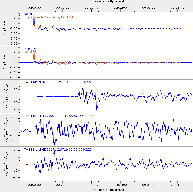
> Station E11A Bogner Ranch, Nez Perce, ID, USA > Earthquake Result Viewer
E11A Bogner Ranch, Nez Perce, ID, USA - Earthquake Result Viewer
| Earthquake location: |
Windward Islands |
| Earthquake latitude/longitude: |
15.0/-61.3 |
| Earthquake time(UTC): |
2007/11/29 (333) 19:00:19 GMT |
| Earthquake Depth: |
148 km |
| Earthquake Magnitude: |
6.9 MB, 7.4 MW, 7.4 MW |
| Earthquake Catalog/Contributor: |
WHDF/NEIC |
|
| Network: |
TA USArray Transportable Network (new EarthScope stations) |
| Station: |
E11A Bogner Ranch, Nez Perce, ID, USA |
| Lat/Lon: |
46.36 N/116.21 W |
| Elevation: |
831 m |
|
| Distance: |
55.3 deg |
| Az: |
316.382 deg |
| Baz: |
105.713 deg |
| Ray Param: |
0.064421505 |
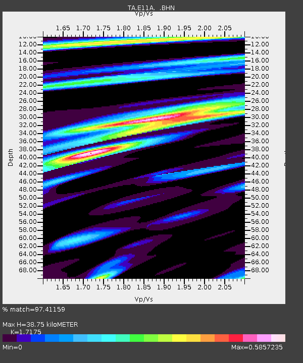
| Estimated Moho Depth: |
38.75 km |
| Estimated Crust Vp/Vs: |
1.72 |
| Assumed Crust Vp: |
6.571 km/s |
| Estimated Crust Vs: |
3.826 km/s |
| Estimated Crust Poisson's Ratio: |
0.24 |
|
| Radial Match: |
97.41159 % |
| Radial Bump: |
236 |
| Transverse Match: |
85.62656 % |
| Transverse Bump: |
400 |
| SOD ConfigId: |
2564 |
| Insert Time: |
2010-03-07 03:11:29.054 +0000 |
| GWidth: |
2.5 |
| Max Bumps: |
400 |
| Tol: |
0.001 |
|
Signal To Noise
| Channel | StoN | STA | LTA |
| TA:E11A: :BHN:20071129T19:09:06.998022Z | 8.585378 | 1.7417556E-6 | 2.0287467E-7 |
| TA:E11A: :BHE:20071129T19:09:06.998022Z | 31.282736 | 5.9048075E-6 | 1.887561E-7 |
| TA:E11A: :BHZ:20071129T19:09:06.998022Z | 48.009106 | 1.2896749E-5 | 2.686313E-7 |
| Arrivals |
| Ps | 4.5 SECOND |
| PpPs | 15 SECOND |
| PsPs/PpSs | 20 SECOND |


