You are here: Home > Network List > TA - USArray Transportable Network (new EarthScope stations) Stations List
> Station E11A Bogner Ranch, Nez Perce, ID, USA > Earthquake Result Viewer
E11A Bogner Ranch, Nez Perce, ID, USA - Earthquake Result Viewer
| Earthquake location: |
Near Coast Of Guatemala |
| Earthquake latitude/longitude: |
13.8/-90.8 |
| Earthquake time(UTC): |
2007/06/08 (159) 13:32:00 GMT |
| Earthquake Depth: |
48 km |
| Earthquake Magnitude: |
5.5 MB, 5.4 MS, 5.8 MW, 5.8 MW |
| Earthquake Catalog/Contributor: |
WHDF/NEIC |
|
| Network: |
TA USArray Transportable Network (new EarthScope stations) |
| Station: |
E11A Bogner Ranch, Nez Perce, ID, USA |
| Lat/Lon: |
46.36 N/116.21 W |
| Elevation: |
831 m |
|
| Distance: |
38.8 deg |
| Az: |
331.676 deg |
| Baz: |
138.285 deg |
| Ray Param: |
0.0752095 |
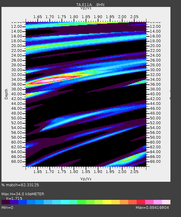
| Estimated Moho Depth: |
34.0 km |
| Estimated Crust Vp/Vs: |
1.72 |
| Assumed Crust Vp: |
6.571 km/s |
| Estimated Crust Vs: |
3.831 km/s |
| Estimated Crust Poisson's Ratio: |
0.24 |
|
| Radial Match: |
82.33125 % |
| Radial Bump: |
400 |
| Transverse Match: |
70.15656 % |
| Transverse Bump: |
400 |
| SOD ConfigId: |
2564 |
| Insert Time: |
2010-03-07 03:12:15.539 +0000 |
| GWidth: |
2.5 |
| Max Bumps: |
400 |
| Tol: |
0.001 |
|

Signal To Noise
| Channel | StoN | STA | LTA |
| TA:E11A: :BHN:20070608T13:38:50.823009Z | 3.132597 | 1.2441161E-7 | 3.9715168E-8 |
| TA:E11A: :BHE:20070608T13:38:50.823009Z | 3.1397953 | 1.347968E-7 | 4.293172E-8 |
| TA:E11A: :BHZ:20070608T13:38:50.823009Z | 6.3559637 | 3.220772E-7 | 5.0673226E-8 |
| Arrivals |
| Ps | 4.0 SECOND |
| PpPs | 13 SECOND |
| PsPs/PpSs | 17 SECOND |


