You are here: Home > Network List > TA - USArray Transportable Network (new EarthScope stations) Stations List
> Station E11A Bogner Ranch, Nez Perce, ID, USA > Earthquake Result Viewer
E11A Bogner Ranch, Nez Perce, ID, USA - Earthquake Result Viewer
| Earthquake location: |
Northern Mid-Atlantic Ridge |
| Earthquake latitude/longitude: |
52.4/-31.8 |
| Earthquake time(UTC): |
2007/05/23 (143) 04:41:46 GMT |
| Earthquake Depth: |
10 km |
| Earthquake Magnitude: |
5.6 MS, 5.4 MB, 5.7 MW, 5.6 MW |
| Earthquake Catalog/Contributor: |
WHDF/NEIC |
|
| Network: |
TA USArray Transportable Network (new EarthScope stations) |
| Station: |
E11A Bogner Ranch, Nez Perce, ID, USA |
| Lat/Lon: |
46.36 N/116.21 W |
| Elevation: |
831 m |
|
| Distance: |
52.3 deg |
| Az: |
299.439 deg |
| Baz: |
50.467 deg |
| Ray Param: |
0.06683177 |
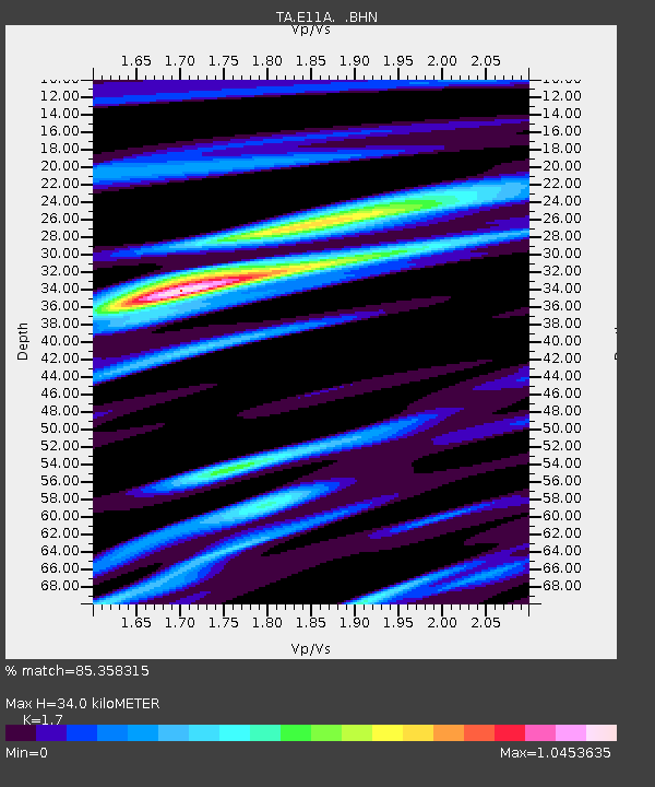
| Estimated Moho Depth: |
34.0 km |
| Estimated Crust Vp/Vs: |
1.70 |
| Assumed Crust Vp: |
6.571 km/s |
| Estimated Crust Vs: |
3.865 km/s |
| Estimated Crust Poisson's Ratio: |
0.24 |
|
| Radial Match: |
85.358315 % |
| Radial Bump: |
400 |
| Transverse Match: |
65.28619 % |
| Transverse Bump: |
400 |
| SOD ConfigId: |
2564 |
| Insert Time: |
2010-03-07 03:12:19.792 +0000 |
| GWidth: |
2.5 |
| Max Bumps: |
400 |
| Tol: |
0.001 |
|

Signal To Noise
| Channel | StoN | STA | LTA |
| TA:E11A: :BHN:20070523T04:50:27.349021Z | 3.8733006 | 2.0039238E-7 | 5.1736855E-8 |
| TA:E11A: :BHE:20070523T04:50:27.349021Z | 5.9992104 | 2.3354306E-7 | 3.8928967E-8 |
| TA:E11A: :BHZ:20070523T04:50:27.349021Z | 9.830953 | 5.4772676E-7 | 5.5714512E-8 |
| Arrivals |
| Ps | 3.8 SECOND |
| PpPs | 13 SECOND |
| PsPs/PpSs | 17 SECOND |


