You are here: Home > Network List > TA - USArray Transportable Network (new EarthScope stations) Stations List
> Station E11A Bogner Ranch, Nez Perce, ID, USA > Earthquake Result Viewer
E11A Bogner Ranch, Nez Perce, ID, USA - Earthquake Result Viewer
| Earthquake location: |
Near West Coast Of Honshu, Japan |
| Earthquake latitude/longitude: |
37.3/136.6 |
| Earthquake time(UTC): |
2007/03/25 (084) 00:41:57 GMT |
| Earthquake Depth: |
8.0 km |
| Earthquake Magnitude: |
6.1 MB, 6.8 MS, 6.7 MW, 6.6 MW |
| Earthquake Catalog/Contributor: |
WHDF/NEIC |
|
| Network: |
TA USArray Transportable Network (new EarthScope stations) |
| Station: |
E11A Bogner Ranch, Nez Perce, ID, USA |
| Lat/Lon: |
46.36 N/116.21 W |
| Elevation: |
831 m |
|
| Distance: |
74.2 deg |
| Az: |
43.441 deg |
| Baz: |
307.692 deg |
| Ray Param: |
0.05250004 |
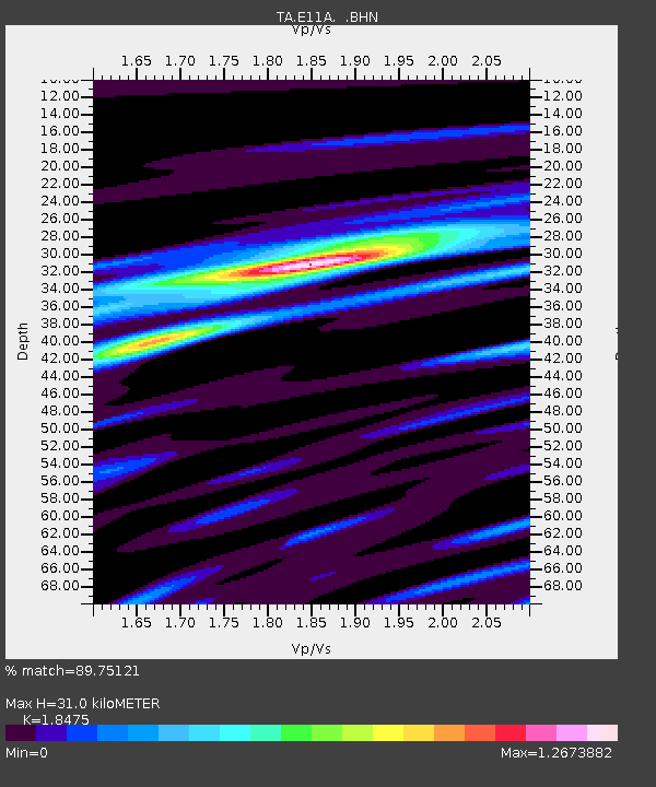
| Estimated Moho Depth: |
31.0 km |
| Estimated Crust Vp/Vs: |
1.85 |
| Assumed Crust Vp: |
6.571 km/s |
| Estimated Crust Vs: |
3.557 km/s |
| Estimated Crust Poisson's Ratio: |
0.29 |
|
| Radial Match: |
89.75121 % |
| Radial Bump: |
400 |
| Transverse Match: |
73.08885 % |
| Transverse Bump: |
400 |
| SOD ConfigId: |
2564 |
| Insert Time: |
2010-03-07 03:12:22.746 +0000 |
| GWidth: |
2.5 |
| Max Bumps: |
400 |
| Tol: |
0.001 |
|

Signal To Noise
| Channel | StoN | STA | LTA |
| TA:E11A: :BHN:20070325T00:53:03.650017Z | 7.178486 | 1.1533127E-6 | 1.606624E-7 |
| TA:E11A: :BHE:20070325T00:53:03.650017Z | 2.6763237 | 1.0956724E-6 | 4.0939457E-7 |
| TA:E11A: :BHZ:20070325T00:53:03.650017Z | 3.3619478 | 3.717656E-6 | 1.1058042E-6 |
| Arrivals |
| Ps | 4.1 SECOND |
| PpPs | 13 SECOND |
| PsPs/PpSs | 17 SECOND |


