You are here: Home > Network List > US - United States National Seismic Network Stations List
> Station AMTX Amarillo, Texas, USA > Earthquake Result Viewer
AMTX Amarillo, Texas, USA - Earthquake Result Viewer
*The percent match for this event was below the threshold and hence no stack was calculated.
| Earthquake location: |
Southern Chile |
| Earthquake latitude/longitude: |
-43.3/-74.4 |
| Earthquake time(UTC): |
2017/01/03 (003) 21:19:07 GMT |
| Earthquake Depth: |
11 km |
| Earthquake Magnitude: |
5.5 Mwr |
| Earthquake Catalog/Contributor: |
NEIC PDE/us |
|
| Network: |
US United States National Seismic Network |
| Station: |
AMTX Amarillo, Texas, USA |
| Lat/Lon: |
34.53 N/101.41 W |
| Elevation: |
1010 m |
|
| Distance: |
81.3 deg |
| Az: |
337.729 deg |
| Baz: |
160.435 deg |
| Ray Param: |
$rayparam |
*The percent match for this event was below the threshold and hence was not used in the summary stack. |
|
| Radial Match: |
51.15944 % |
| Radial Bump: |
400 |
| Transverse Match: |
35.82962 % |
| Transverse Bump: |
400 |
| SOD ConfigId: |
1943534 |
| Insert Time: |
2017-01-17 21:22:17.746 +0000 |
| GWidth: |
2.5 |
| Max Bumps: |
400 |
| Tol: |
0.001 |
|
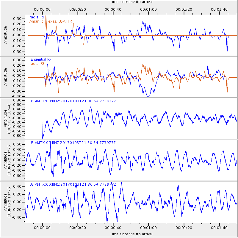
Signal To Noise
| Channel | StoN | STA | LTA |
| US:AMTX:00:BHZ:20170103T21:30:54.773977Z | 1.5405476 | 3.098011E-7 | 2.0109805E-7 |
| US:AMTX:00:BH1:20170103T21:30:54.773977Z | 0.5687149 | 1.0909009E-7 | 1.9181859E-7 |
| US:AMTX:00:BH2:20170103T21:30:54.773977Z | 1.182723 | 3.485857E-7 | 2.9473148E-7 |
| Arrivals |
| Ps | |
| PpPs | |
| PsPs/PpSs | |


