You are here: Home > Network List > US - United States National Seismic Network Stations List
> Station WMOK Wichita Mountains, Oklahoma, USA > Earthquake Result Viewer
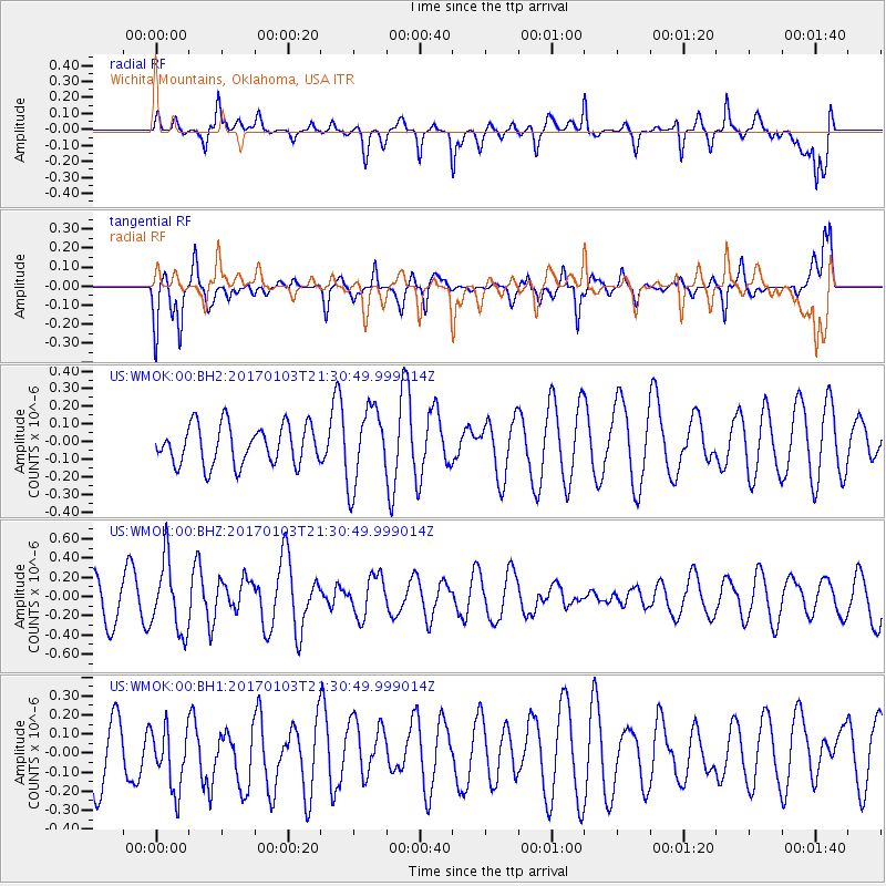
WMOK Wichita Mountains, Oklahoma, USA - Earthquake Result Viewer
*The percent match for this event was below the threshold and hence no stack was calculated.
| Earthquake location: |
Southern Chile |
| Earthquake latitude/longitude: |
-43.3/-74.4 |
| Earthquake time(UTC): |
2017/01/03 (003) 21:19:07 GMT |
| Earthquake Depth: |
11 km |
| Earthquake Magnitude: |
5.5 Mwr |
| Earthquake Catalog/Contributor: |
NEIC PDE/us |
|
| Network: |
US United States National Seismic Network |
| Station: |
WMOK Wichita Mountains, Oklahoma, USA |
| Lat/Lon: |
34.74 N/98.78 W |
| Elevation: |
486 m |
|
| Distance: |
80.8 deg |
| Az: |
339.873 deg |
| Baz: |
162.254 deg |
| Ray Param: |
$rayparam |
*The percent match for this event was below the threshold and hence was not used in the summary stack. |
|
| Radial Match: |
63.822647 % |
| Radial Bump: |
400 |
| Transverse Match: |
69.95498 % |
| Transverse Bump: |
394 |
| SOD ConfigId: |
1943534 |
| Insert Time: |
2017-01-17 21:22:52.571 +0000 |
| GWidth: |
2.5 |
| Max Bumps: |
400 |
| Tol: |
0.001 |
|
Signal To Noise
| Channel | StoN | STA | LTA |
| US:WMOK:00:BHZ:20170103T21:30:49.999014Z | 2.419648 | 3.6570415E-7 | 1.511394E-7 |
| US:WMOK:00:BH1:20170103T21:30:49.999014Z | 0.748372 | 1.6445553E-7 | 2.1975103E-7 |
| US:WMOK:00:BH2:20170103T21:30:49.999014Z | 1.9473065 | 2.169303E-7 | 1.1140018E-7 |
| Arrivals |
| Ps | |
| PpPs | |
| PsPs/PpSs | |


