You are here: Home > Network List > TA - USArray Transportable Network (new EarthScope stations) Stations List
> Station S12A Delamar Landing Field, Caliente, NV, USA > Earthquake Result Viewer
S12A Delamar Landing Field, Caliente, NV, USA - Earthquake Result Viewer
| Earthquake location: |
Svalbard Region |
| Earthquake latitude/longitude: |
77.1/18.6 |
| Earthquake time(UTC): |
2008/02/21 (052) 02:46:17 GMT |
| Earthquake Depth: |
10 km |
| Earthquake Magnitude: |
5.7 MB, 5.9 MS, 6.1 MW, 6.0 MW |
| Earthquake Catalog/Contributor: |
WHDF/NEIC |
|
| Network: |
TA USArray Transportable Network (new EarthScope stations) |
| Station: |
S12A Delamar Landing Field, Caliente, NV, USA |
| Lat/Lon: |
37.61 N/114.85 W |
| Elevation: |
1479 m |
|
| Distance: |
62.0 deg |
| Az: |
319.216 deg |
| Baz: |
10.666 deg |
| Ray Param: |
0.060507398 |
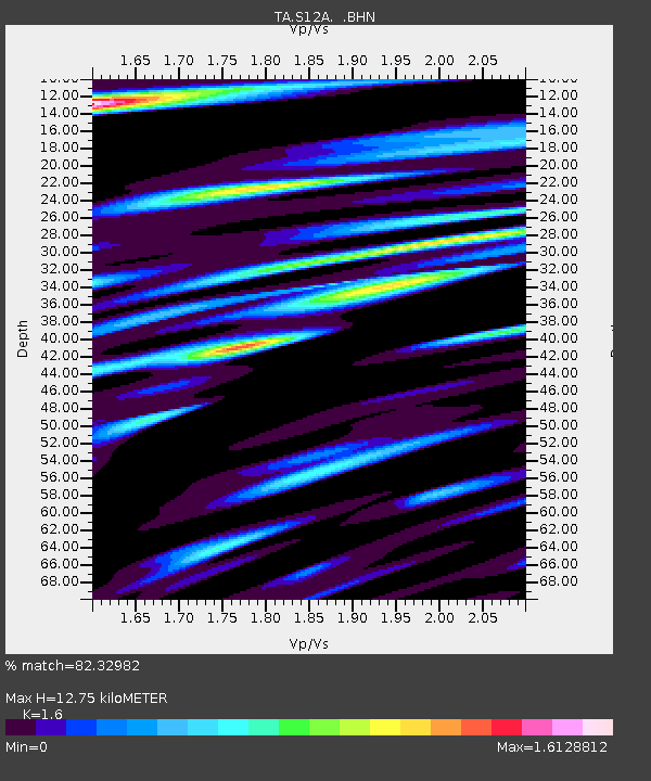
| Estimated Moho Depth: |
12.75 km |
| Estimated Crust Vp/Vs: |
1.60 |
| Assumed Crust Vp: |
6.276 km/s |
| Estimated Crust Vs: |
3.922 km/s |
| Estimated Crust Poisson's Ratio: |
0.18 |
|
| Radial Match: |
82.32982 % |
| Radial Bump: |
400 |
| Transverse Match: |
73.730484 % |
| Transverse Bump: |
400 |
| SOD ConfigId: |
2564 |
| Insert Time: |
2010-03-07 03:12:35.419 +0000 |
| GWidth: |
2.5 |
| Max Bumps: |
400 |
| Tol: |
0.001 |
|
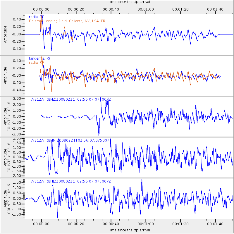
Signal To Noise
| Channel | StoN | STA | LTA |
| TA:S12A: :BHN:20080221T02:56:07.075007Z | 4.166319 | 7.072744E-7 | 1.6976003E-7 |
| TA:S12A: :BHE:20080221T02:56:07.075007Z | 1.7020694 | 3.1166047E-7 | 1.831068E-7 |
| TA:S12A: :BHZ:20080221T02:56:07.075007Z | 11.459384 | 1.3641483E-6 | 1.1904202E-7 |
| Arrivals |
| Ps | 1.3 SECOND |
| PpPs | 5.0 SECOND |
| PsPs/PpSs | 6.3 SECOND |


