You are here: Home > Network List > TA - USArray Transportable Network (new EarthScope stations) Stations List
> Station G21K Allakaket, AK, USA > Earthquake Result Viewer
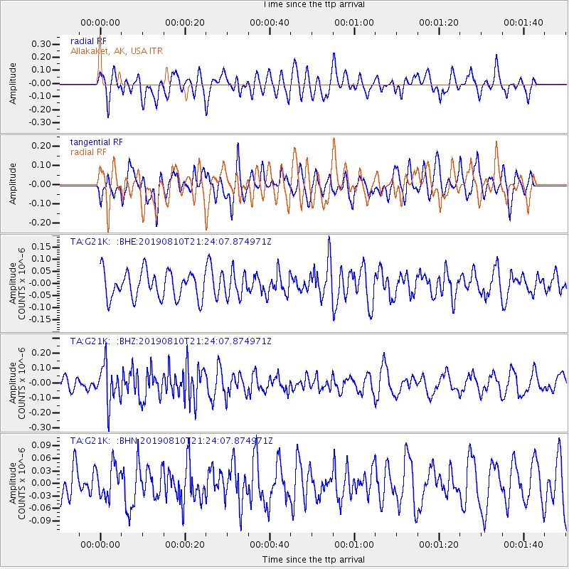
G21K Allakaket, AK, USA - Earthquake Result Viewer
*The percent match for this event was below the threshold and hence no stack was calculated.
| Earthquake location: |
Southern Sumatra, Indonesia |
| Earthquake latitude/longitude: |
-0.8/99.4 |
| Earthquake time(UTC): |
2019/08/10 (222) 21:11:11 GMT |
| Earthquake Depth: |
51 km |
| Earthquake Magnitude: |
5.6 mb |
| Earthquake Catalog/Contributor: |
NEIC PDE/us |
|
| Network: |
TA USArray Transportable Network (new EarthScope stations) |
| Station: |
G21K Allakaket, AK, USA |
| Lat/Lon: |
66.52 N/153.51 W |
| Elevation: |
446 m |
|
| Distance: |
97.5 deg |
| Az: |
22.722 deg |
| Baz: |
285.478 deg |
| Ray Param: |
$rayparam |
*The percent match for this event was below the threshold and hence was not used in the summary stack. |
|
| Radial Match: |
54.241756 % |
| Radial Bump: |
400 |
| Transverse Match: |
49.883812 % |
| Transverse Bump: |
400 |
| SOD ConfigId: |
19053131 |
| Insert Time: |
2019-08-24 21:16:19.925 +0000 |
| GWidth: |
2.5 |
| Max Bumps: |
400 |
| Tol: |
0.001 |
|
Signal To Noise
| Channel | StoN | STA | LTA |
| TA:G21K: :BHZ:20190810T21:24:07.874971Z | 2.8499053 | 1.2656136E-7 | 4.440897E-8 |
| TA:G21K: :BHN:20190810T21:24:07.874971Z | 0.8133939 | 3.7570263E-8 | 4.618951E-8 |
| TA:G21K: :BHE:20190810T21:24:07.874971Z | 0.9040828 | 5.0264923E-8 | 5.5597702E-8 |
| Arrivals |
| Ps | |
| PpPs | |
| PsPs/PpSs | |


