You are here: Home > Network List > TA - USArray Transportable Network (new EarthScope stations) Stations List
> Station S12A Delamar Landing Field, Caliente, NV, USA > Earthquake Result Viewer
S12A Delamar Landing Field, Caliente, NV, USA - Earthquake Result Viewer
| Earthquake location: |
Near Coast Of Peru |
| Earthquake latitude/longitude: |
-13.4/-76.6 |
| Earthquake time(UTC): |
2007/08/15 (227) 23:40:57 GMT |
| Earthquake Depth: |
39 km |
| Earthquake Magnitude: |
6.7 MB, 7.9 MS, 8.0 MW, 7.5 ME |
| Earthquake Catalog/Contributor: |
WHDF/NEIC |
|
| Network: |
TA USArray Transportable Network (new EarthScope stations) |
| Station: |
S12A Delamar Landing Field, Caliente, NV, USA |
| Lat/Lon: |
37.61 N/114.85 W |
| Elevation: |
1479 m |
|
| Distance: |
62.1 deg |
| Az: |
326.218 deg |
| Baz: |
137.049 deg |
| Ray Param: |
0.06034425 |
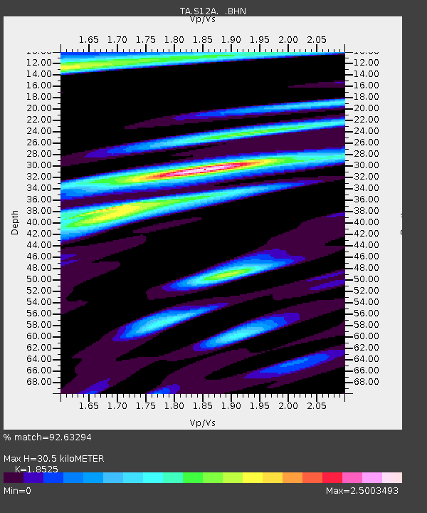
| Estimated Moho Depth: |
30.5 km |
| Estimated Crust Vp/Vs: |
1.85 |
| Assumed Crust Vp: |
6.276 km/s |
| Estimated Crust Vs: |
3.388 km/s |
| Estimated Crust Poisson's Ratio: |
0.29 |
|
| Radial Match: |
92.63294 % |
| Radial Bump: |
400 |
| Transverse Match: |
80.5649 % |
| Transverse Bump: |
400 |
| SOD ConfigId: |
2564 |
| Insert Time: |
2010-03-07 03:12:52.935 +0000 |
| GWidth: |
2.5 |
| Max Bumps: |
400 |
| Tol: |
0.001 |
|
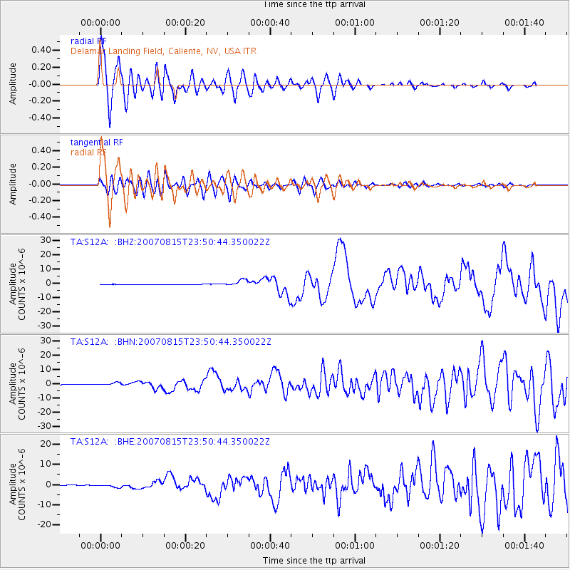
Signal To Noise
| Channel | StoN | STA | LTA |
| TA:S12A: :BHN:20070815T23:50:44.350022Z | 8.047411 | 9.990141E-7 | 1.2414107E-7 |
| TA:S12A: :BHE:20070815T23:50:44.350022Z | 8.937787 | 8.182419E-7 | 9.154861E-8 |
| TA:S12A: :BHZ:20070815T23:50:44.350022Z | 21.411072 | 2.2769116E-6 | 1.0634271E-7 |
| Arrivals |
| Ps | 4.3 SECOND |
| PpPs | 13 SECOND |
| PsPs/PpSs | 18 SECOND |


