You are here: Home > Network List > G - GEOSCOPE Stations List
> Station DRV Dumont d'Urville, Terre Adelie (Antartica) > Earthquake Result Viewer
DRV Dumont d'Urville, Terre Adelie (Antartica) - Earthquake Result Viewer

| Earthquake location: |
South Of Fiji Islands |
| Earthquake latitude/longitude: |
-19.3/176.1 |
| Earthquake time(UTC): |
2017/01/03 (003) 21:52:31 GMT |
| Earthquake Depth: |
17 km |
| Earthquake Magnitude: |
6.9 Mww |
| Earthquake Catalog/Contributor: |
NEIC PDE/us |
|
| Network: |
G GEOSCOPE |
| Station: |
DRV Dumont d'Urville, Terre Adelie (Antartica) |
| Lat/Lon: |
66.67 S/140.01 E |
| Elevation: |
40 m |
|
| Distance: |
52.7 deg |
| Az: |
197.135 deg |
| Baz: |
44.302 deg |
| Ray Param: |
0.06657107 |
| Estimated Moho Depth: |
42.25 km |
| Estimated Crust Vp/Vs: |
1.74 |
| Assumed Crust Vp: |
6.39 km/s |
| Estimated Crust Vs: |
3.672 km/s |
| Estimated Crust Poisson's Ratio: |
0.25 |
|
| Radial Match: |
98.43395 % |
| Radial Bump: |
226 |
| Transverse Match: |
88.94166 % |
| Transverse Bump: |
400 |
| SOD ConfigId: |
1943534 |
| Insert Time: |
2017-01-17 21:53:16.323 +0000 |
| GWidth: |
2.5 |
| Max Bumps: |
400 |
| Tol: |
0.001 |
|
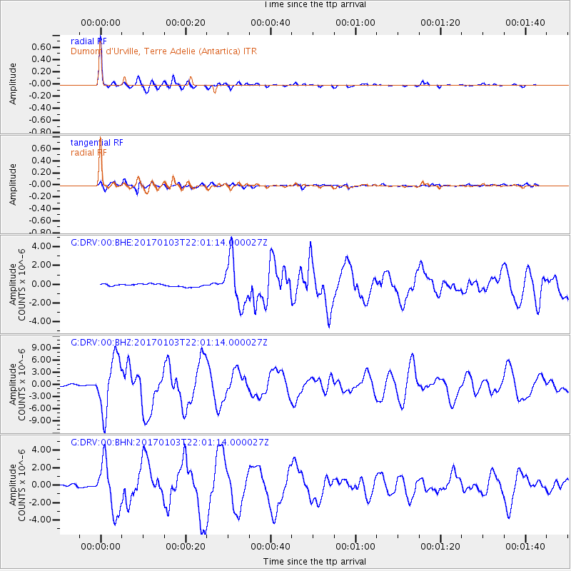
Signal To Noise
| Channel | StoN | STA | LTA |
| G:DRV:00:BHZ:20170103T22:01:14.000027Z | 40.833035 | 6.6835037E-6 | 1.6367885E-7 |
| G:DRV:00:BHN:20170103T22:01:14.000027Z | 21.963938 | 2.9031692E-6 | 1.321789E-7 |
| G:DRV:00:BHE:20170103T22:01:14.000027Z | 18.119219 | 2.5440809E-6 | 1.4040786E-7 |
| Arrivals |
| Ps | 5.2 SECOND |
| PpPs | 17 SECOND |
| PsPs/PpSs | 22 SECOND |


