You are here: Home > Network List > TA - USArray Transportable Network (new EarthScope stations) Stations List
> Station S12A Delamar Landing Field, Caliente, NV, USA > Earthquake Result Viewer
S12A Delamar Landing Field, Caliente, NV, USA - Earthquake Result Viewer
| Earthquake location: |
Solomon Islands |
| Earthquake latitude/longitude: |
-8.5/157.0 |
| Earthquake time(UTC): |
2007/04/01 (091) 20:39:56 GMT |
| Earthquake Depth: |
10 km |
| Earthquake Magnitude: |
6.8 MB, 7.9 MS, 8.1 MW, 7.7 ME |
| Earthquake Catalog/Contributor: |
WHDF/NEIC |
|
| Network: |
TA USArray Transportable Network (new EarthScope stations) |
| Station: |
S12A Delamar Landing Field, Caliente, NV, USA |
| Lat/Lon: |
37.61 N/114.85 W |
| Elevation: |
1479 m |
|
| Distance: |
93.6 deg |
| Az: |
52.685 deg |
| Baz: |
262.172 deg |
| Ray Param: |
0.041227836 |
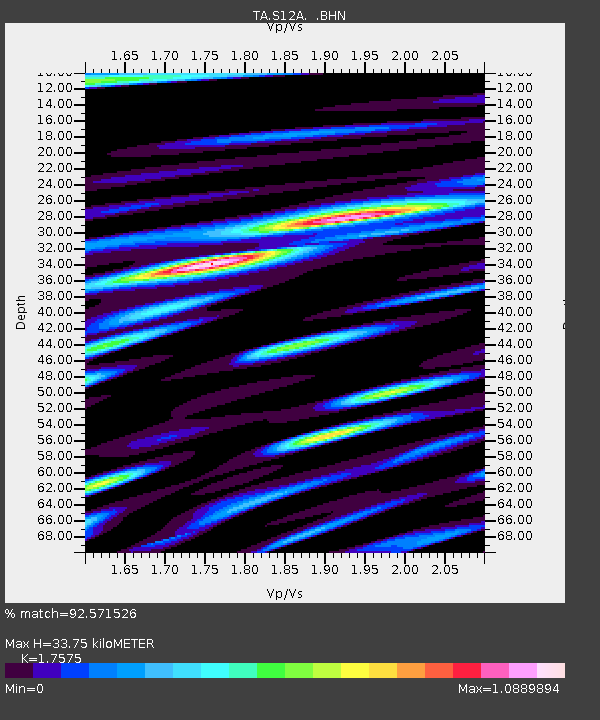
| Estimated Moho Depth: |
33.75 km |
| Estimated Crust Vp/Vs: |
1.76 |
| Assumed Crust Vp: |
6.276 km/s |
| Estimated Crust Vs: |
3.571 km/s |
| Estimated Crust Poisson's Ratio: |
0.26 |
|
| Radial Match: |
92.571526 % |
| Radial Bump: |
400 |
| Transverse Match: |
85.262146 % |
| Transverse Bump: |
400 |
| SOD ConfigId: |
2564 |
| Insert Time: |
2010-03-07 03:13:10.638 +0000 |
| GWidth: |
2.5 |
| Max Bumps: |
400 |
| Tol: |
0.001 |
|
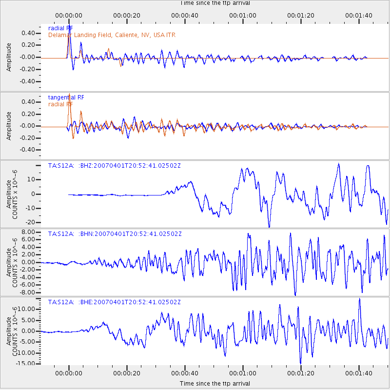
Signal To Noise
| Channel | StoN | STA | LTA |
| TA:S12A: :BHN:20070401T20:52:41.02502Z | 1.58063 | 2.9712828E-7 | 1.8798092E-7 |
| TA:S12A: :BHE:20070401T20:52:41.02502Z | 1.9060066 | 4.0681712E-7 | 2.1343952E-7 |
| TA:S12A: :BHZ:20070401T20:52:41.02502Z | 4.5969563 | 9.647852E-7 | 2.0987477E-7 |
| Arrivals |
| Ps | 4.2 SECOND |
| PpPs | 15 SECOND |
| PsPs/PpSs | 19 SECOND |


