You are here: Home > Network List > TA - USArray Transportable Network (new EarthScope stations) Stations List
> Station S12A Delamar Landing Field, Caliente, NV, USA > Earthquake Result Viewer
S12A Delamar Landing Field, Caliente, NV, USA - Earthquake Result Viewer
| Earthquake location: |
South Of Fiji Islands |
| Earthquake latitude/longitude: |
-26.0/-177.5 |
| Earthquake time(UTC): |
2007/12/09 (343) 07:28:20 GMT |
| Earthquake Depth: |
152 km |
| Earthquake Magnitude: |
7.0 MB, 7.8 MW, 7.7 MW |
| Earthquake Catalog/Contributor: |
WHDF/NEIC |
|
| Network: |
TA USArray Transportable Network (new EarthScope stations) |
| Station: |
S12A Delamar Landing Field, Caliente, NV, USA |
| Lat/Lon: |
37.61 N/114.85 W |
| Elevation: |
1479 m |
|
| Distance: |
86.4 deg |
| Az: |
44.984 deg |
| Baz: |
233.234 deg |
| Ray Param: |
0.043753885 |
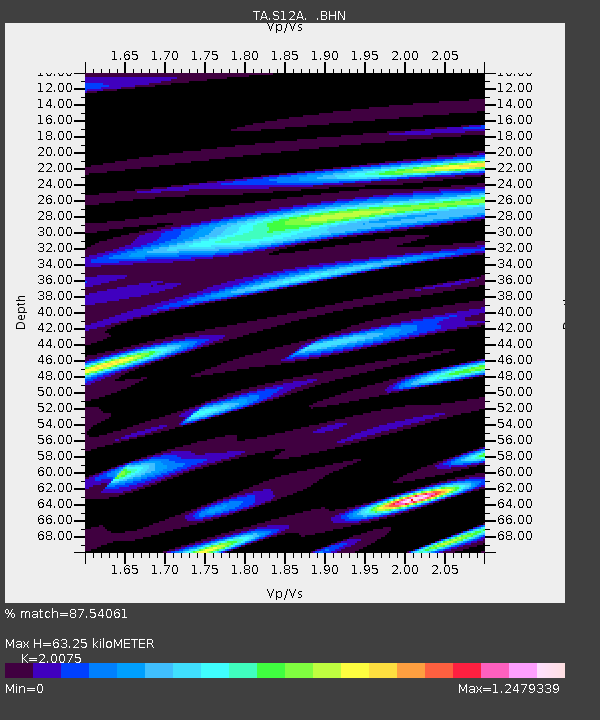
| Estimated Moho Depth: |
63.25 km |
| Estimated Crust Vp/Vs: |
2.01 |
| Assumed Crust Vp: |
6.276 km/s |
| Estimated Crust Vs: |
3.126 km/s |
| Estimated Crust Poisson's Ratio: |
0.33 |
|
| Radial Match: |
87.54061 % |
| Radial Bump: |
400 |
| Transverse Match: |
77.02874 % |
| Transverse Bump: |
400 |
| SOD ConfigId: |
2564 |
| Insert Time: |
2010-03-07 03:13:13.563 +0000 |
| GWidth: |
2.5 |
| Max Bumps: |
400 |
| Tol: |
0.001 |
|
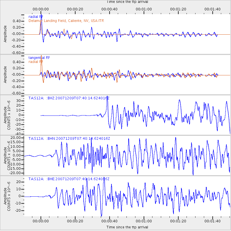
Signal To Noise
| Channel | StoN | STA | LTA |
| TA:S12A: :BHN:20071209T07:40:14.624016Z | 2.053597 | 5.563155E-7 | 2.7089808E-7 |
| TA:S12A: :BHE:20071209T07:40:14.624016Z | 3.4506247 | 6.9043904E-7 | 2.0009102E-7 |
| TA:S12A: :BHZ:20071209T07:40:14.624016Z | 4.0172567 | 1.3938068E-6 | 3.4695486E-7 |
| Arrivals |
| Ps | 10 SECOND |
| PpPs | 30 SECOND |
| PsPs/PpSs | 40 SECOND |


