You are here: Home > Network List > TS - TERRAscope (Southern California Seismic Network) Stations List
> Station MLAC Mammoth Lakes, California, USA > Earthquake Result Viewer
MLAC Mammoth Lakes, California, USA - Earthquake Result Viewer
*The percent match for this event was below the threshold and hence no stack was calculated.
| Earthquake location: |
South Of Kermadec Islands |
| Earthquake latitude/longitude: |
-32.5/-179.0 |
| Earthquake time(UTC): |
1996/11/11 (316) 00:47:21 GMT |
| Earthquake Depth: |
33 km |
| Earthquake Magnitude: |
5.9 MB, 5.9 MS, 6.1 UNKNOWN, 6.0 MW |
| Earthquake Catalog/Contributor: |
WHDF/NEIC |
|
| Network: |
TS TERRAscope (Southern California Seismic Network) |
| Station: |
MLAC Mammoth Lakes, California, USA |
| Lat/Lon: |
37.63 N/118.83 W |
| Elevation: |
2170 m |
|
| Distance: |
89.6 deg |
| Az: |
43.557 deg |
| Baz: |
227.147 deg |
| Ray Param: |
$rayparam |
*The percent match for this event was below the threshold and hence was not used in the summary stack. |
|
| Radial Match: |
62.825783 % |
| Radial Bump: |
400 |
| Transverse Match: |
75.37477 % |
| Transverse Bump: |
400 |
| SOD ConfigId: |
4480 |
| Insert Time: |
2010-02-26 14:25:28.229 +0000 |
| GWidth: |
2.5 |
| Max Bumps: |
400 |
| Tol: |
0.001 |
|
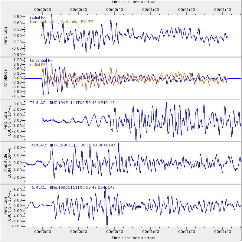
Signal To Noise
| Channel | StoN | STA | LTA |
| TS:MLAC: :BHN:19961111T00:59:43.964014Z | 2.7181497 | 7.046018E-7 | 2.5922114E-7 |
| TS:MLAC: :BHE:19961111T00:59:43.964014Z | 0.29148465 | 1.7006685E-7 | 5.8345046E-7 |
| TS:MLAC: :BHZ:19961111T00:59:43.964014Z | 2.6442268 | 7.1854095E-7 | 2.7173954E-7 |
| Arrivals |
| Ps | |
| PpPs | |
| PsPs/PpSs | |


