You are here: Home > Network List > TA - USArray Transportable Network (new EarthScope stations) Stations List
> Station Q10A Clear Creek Ranch, Tonopah, NV, USA > Earthquake Result Viewer
Q10A Clear Creek Ranch, Tonopah, NV, USA - Earthquake Result Viewer

| Earthquake location: |
South Of Fiji Islands |
| Earthquake latitude/longitude: |
-25.8/179.5 |
| Earthquake time(UTC): |
2007/10/16 (289) 21:05:43 GMT |
| Earthquake Depth: |
509 km |
| Earthquake Magnitude: |
6.2 MB, 6.6 MW, 6.5 MW |
| Earthquake Catalog/Contributor: |
WHDF/NEIC |
|
| Network: |
TA USArray Transportable Network (new EarthScope stations) |
| Station: |
Q10A Clear Creek Ranch, Tonopah, NV, USA |
| Lat/Lon: |
38.82 N/116.40 W |
| Elevation: |
2027 m |
|
| Distance: |
87.8 deg |
| Az: |
44.667 deg |
| Baz: |
234.239 deg |
| Ray Param: |
0.041725215 |
| Estimated Moho Depth: |
46.25 km |
| Estimated Crust Vp/Vs: |
1.64 |
| Assumed Crust Vp: |
6.276 km/s |
| Estimated Crust Vs: |
3.815 km/s |
| Estimated Crust Poisson's Ratio: |
0.21 |
|
| Radial Match: |
89.88886 % |
| Radial Bump: |
400 |
| Transverse Match: |
83.8835 % |
| Transverse Bump: |
400 |
| SOD ConfigId: |
2564 |
| Insert Time: |
2010-03-07 03:13:46.040 +0000 |
| GWidth: |
2.5 |
| Max Bumps: |
400 |
| Tol: |
0.001 |
|
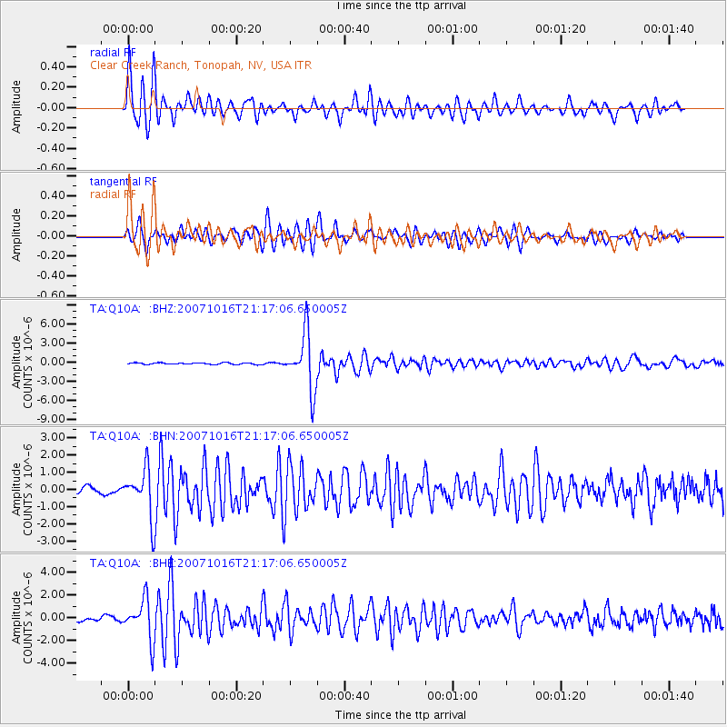
Signal To Noise
| Channel | StoN | STA | LTA |
| TA:Q10A: :BHN:20071016T21:17:06.650005Z | 6.4120784 | 1.4291372E-6 | 2.2288206E-7 |
| TA:Q10A: :BHE:20071016T21:17:06.650005Z | 12.329012 | 1.7689865E-6 | 1.4348161E-7 |
| TA:Q10A: :BHZ:20071016T21:17:06.650005Z | 36.72058 | 4.5133484E-6 | 1.2291059E-7 |
| Arrivals |
| Ps | 4.9 SECOND |
| PpPs | 19 SECOND |
| PsPs/PpSs | 24 SECOND |


