You are here: Home > Network List > TA - USArray Transportable Network (new EarthScope stations) Stations List
> Station Q10A Clear Creek Ranch, Tonopah, NV, USA > Earthquake Result Viewer
Q10A Clear Creek Ranch, Tonopah, NV, USA - Earthquake Result Viewer
| Earthquake location: |
Near Coast Of Peru |
| Earthquake latitude/longitude: |
-13.6/-76.6 |
| Earthquake time(UTC): |
2007/08/19 (231) 01:22:40 GMT |
| Earthquake Depth: |
26 km |
| Earthquake Magnitude: |
5.9 MB, 5.4 MS, 5.8 MW, 5.5 ML |
| Earthquake Catalog/Contributor: |
WHDF/NEIC |
|
| Network: |
TA USArray Transportable Network (new EarthScope stations) |
| Station: |
Q10A Clear Creek Ranch, Tonopah, NV, USA |
| Lat/Lon: |
38.82 N/116.40 W |
| Elevation: |
2027 m |
|
| Distance: |
64.1 deg |
| Az: |
326.232 deg |
| Baz: |
136.227 deg |
| Ray Param: |
0.05912985 |
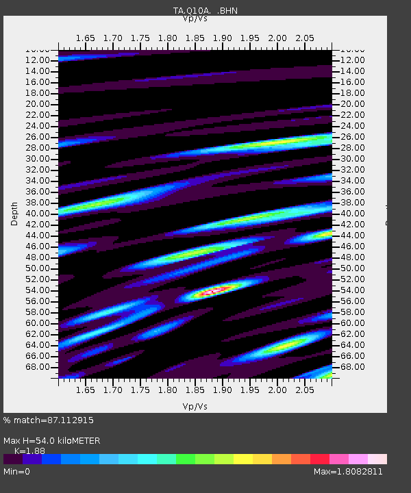
| Estimated Moho Depth: |
54.0 km |
| Estimated Crust Vp/Vs: |
1.88 |
| Assumed Crust Vp: |
6.276 km/s |
| Estimated Crust Vs: |
3.338 km/s |
| Estimated Crust Poisson's Ratio: |
0.30 |
|
| Radial Match: |
87.112915 % |
| Radial Bump: |
400 |
| Transverse Match: |
86.50069 % |
| Transverse Bump: |
400 |
| SOD ConfigId: |
2564 |
| Insert Time: |
2010-03-07 03:13:59.791 +0000 |
| GWidth: |
2.5 |
| Max Bumps: |
400 |
| Tol: |
0.001 |
|

Signal To Noise
| Channel | StoN | STA | LTA |
| TA:Q10A: :BHN:20070819T01:32:41.149014Z | 1.3970239 | 1.666711E-7 | 1.193044E-7 |
| TA:Q10A: :BHE:20070819T01:32:41.149014Z | 1.3325138 | 1.471533E-7 | 1.1043285E-7 |
| TA:Q10A: :BHZ:20070819T01:32:41.149014Z | 3.4740596 | 2.875105E-7 | 8.275923E-8 |
| Arrivals |
| Ps | 7.9 SECOND |
| PpPs | 24 SECOND |
| PsPs/PpSs | 32 SECOND |


