You are here: Home > Network List > TA - USArray Transportable Network (new EarthScope stations) Stations List
> Station Q10A Clear Creek Ranch, Tonopah, NV, USA > Earthquake Result Viewer
Q10A Clear Creek Ranch, Tonopah, NV, USA - Earthquake Result Viewer
| Earthquake location: |
Near Coast Of Peru |
| Earthquake latitude/longitude: |
-13.6/-76.6 |
| Earthquake time(UTC): |
2007/08/17 (229) 13:18:13 GMT |
| Earthquake Depth: |
48 km |
| Earthquake Magnitude: |
5.6 MB, 5.6 MS, 5.9 MW |
| Earthquake Catalog/Contributor: |
WHDF/NEIC |
|
| Network: |
TA USArray Transportable Network (new EarthScope stations) |
| Station: |
Q10A Clear Creek Ranch, Tonopah, NV, USA |
| Lat/Lon: |
38.82 N/116.40 W |
| Elevation: |
2027 m |
|
| Distance: |
64.1 deg |
| Az: |
326.217 deg |
| Baz: |
136.199 deg |
| Ray Param: |
0.05907027 |
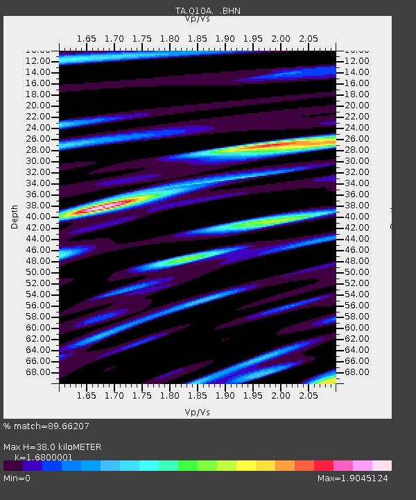
| Estimated Moho Depth: |
38.0 km |
| Estimated Crust Vp/Vs: |
1.68 |
| Assumed Crust Vp: |
6.276 km/s |
| Estimated Crust Vs: |
3.736 km/s |
| Estimated Crust Poisson's Ratio: |
0.23 |
|
| Radial Match: |
89.66207 % |
| Radial Bump: |
400 |
| Transverse Match: |
89.12364 % |
| Transverse Bump: |
400 |
| SOD ConfigId: |
2564 |
| Insert Time: |
2010-03-07 03:14:01.881 +0000 |
| GWidth: |
2.5 |
| Max Bumps: |
400 |
| Tol: |
0.001 |
|

Signal To Noise
| Channel | StoN | STA | LTA |
| TA:Q10A: :BHN:20070817T13:28:11.250029Z | 5.7533345 | 2.8259018E-7 | 4.9117634E-8 |
| TA:Q10A: :BHE:20070817T13:28:11.250029Z | 2.111651 | 1.870516E-7 | 8.8580734E-8 |
| TA:Q10A: :BHZ:20070817T13:28:11.250029Z | 10.5233555 | 6.482424E-7 | 6.160035E-8 |
| Arrivals |
| Ps | 4.3 SECOND |
| PpPs | 16 SECOND |
| PsPs/PpSs | 20 SECOND |


