You are here: Home > Network List > TA - USArray Transportable Network (new EarthScope stations) Stations List
> Station Q10A Clear Creek Ranch, Tonopah, NV, USA > Earthquake Result Viewer
Q10A Clear Creek Ranch, Tonopah, NV, USA - Earthquake Result Viewer

| Earthquake location: |
Andreanof Islands, Aleutian Is. |
| Earthquake latitude/longitude: |
51.3/-180.0 |
| Earthquake time(UTC): |
2007/08/02 (214) 03:21:42 GMT |
| Earthquake Depth: |
21 km |
| Earthquake Magnitude: |
6.3 MB, 6.6 MS, 6.7 MW, 6.6 MW |
| Earthquake Catalog/Contributor: |
WHDF/NEIC |
|
| Network: |
TA USArray Transportable Network (new EarthScope stations) |
| Station: |
Q10A Clear Creek Ranch, Tonopah, NV, USA |
| Lat/Lon: |
38.82 N/116.40 W |
| Elevation: |
2027 m |
|
| Distance: |
45.2 deg |
| Az: |
80.163 deg |
| Baz: |
307.648 deg |
| Ray Param: |
0.07138624 |
| Estimated Moho Depth: |
38.5 km |
| Estimated Crust Vp/Vs: |
1.74 |
| Assumed Crust Vp: |
6.276 km/s |
| Estimated Crust Vs: |
3.612 km/s |
| Estimated Crust Poisson's Ratio: |
0.25 |
|
| Radial Match: |
85.13323 % |
| Radial Bump: |
400 |
| Transverse Match: |
90.03262 % |
| Transverse Bump: |
400 |
| SOD ConfigId: |
2564 |
| Insert Time: |
2010-03-07 03:14:06.801 +0000 |
| GWidth: |
2.5 |
| Max Bumps: |
400 |
| Tol: |
0.001 |
|
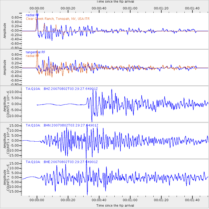
Signal To Noise
| Channel | StoN | STA | LTA |
| TA:Q10A: :BHN:20070802T03:29:27.64901Z | 1.5758972 | 7.2127955E-7 | 4.576945E-7 |
| TA:Q10A: :BHE:20070802T03:29:27.64901Z | 1.6425763 | 1.2271249E-6 | 7.470733E-7 |
| TA:Q10A: :BHZ:20070802T03:29:27.64901Z | 6.5840483 | 2.648169E-6 | 4.0220985E-7 |
| Arrivals |
| Ps | 4.8 SECOND |
| PpPs | 16 SECOND |
| PsPs/PpSs | 21 SECOND |


