You are here: Home > Network List > IU - Global Seismograph Network (GSN - IRIS/USGS) Stations List
> Station JOHN Johnston Island, USA > Earthquake Result Viewer
JOHN Johnston Island, USA - Earthquake Result Viewer
| Earthquake location: |
South Of Fiji Islands |
| Earthquake latitude/longitude: |
-19.3/176.1 |
| Earthquake time(UTC): |
2017/01/03 (003) 21:52:31 GMT |
| Earthquake Depth: |
17 km |
| Earthquake Magnitude: |
6.9 Mww |
| Earthquake Catalog/Contributor: |
NEIC PDE/us |
|
| Network: |
IU Global Seismograph Network (GSN - IRIS/USGS) |
| Station: |
JOHN Johnston Island, USA |
| Lat/Lon: |
16.73 N/169.53 W |
| Elevation: |
2.0 m |
|
| Distance: |
38.5 deg |
| Az: |
22.518 deg |
| Baz: |
202.175 deg |
| Ray Param: |
0.075487755 |
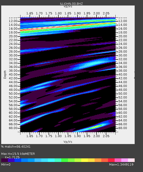
| Estimated Moho Depth: |
15.5 km |
| Estimated Crust Vp/Vs: |
1.71 |
| Assumed Crust Vp: |
4.24 km/s |
| Estimated Crust Vs: |
2.476 km/s |
| Estimated Crust Poisson's Ratio: |
0.24 |
|
| Radial Match: |
86.40241 % |
| Radial Bump: |
289 |
| Transverse Match: |
56.001453 % |
| Transverse Bump: |
400 |
| SOD ConfigId: |
1943534 |
| Insert Time: |
2017-01-17 21:54:06.749 +0000 |
| GWidth: |
2.5 |
| Max Bumps: |
400 |
| Tol: |
0.001 |
|
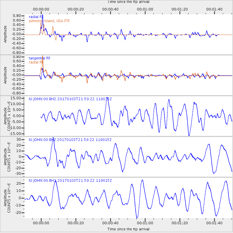
Signal To Noise
| Channel | StoN | STA | LTA |
| IU:JOHN:00:BHZ:20170103T21:59:22.119015Z | 2.6436226 | 6.672685E-6 | 2.5240686E-6 |
| IU:JOHN:00:BH1:20170103T21:59:22.119015Z | 1.0147369 | 4.2502957E-6 | 4.188569E-6 |
| IU:JOHN:00:BH2:20170103T21:59:22.119015Z | 0.8001432 | 2.1958504E-6 | 2.7443218E-6 |
| Arrivals |
| Ps | 2.7 SECOND |
| PpPs | 9.6 SECOND |
| PsPs/PpSs | 12 SECOND |


