You are here: Home > Network List > IU - Global Seismograph Network (GSN - IRIS/USGS) Stations List
> Station NWAO Narrogin, Australia > Earthquake Result Viewer
NWAO Narrogin, Australia - Earthquake Result Viewer
| Earthquake location: |
South Of Fiji Islands |
| Earthquake latitude/longitude: |
-19.3/176.1 |
| Earthquake time(UTC): |
2017/01/03 (003) 21:52:31 GMT |
| Earthquake Depth: |
17 km |
| Earthquake Magnitude: |
6.9 Mww |
| Earthquake Catalog/Contributor: |
NEIC PDE/us |
|
| Network: |
IU Global Seismograph Network (GSN - IRIS/USGS) |
| Station: |
NWAO Narrogin, Australia |
| Lat/Lon: |
32.93 S/117.24 E |
| Elevation: |
380 m |
|
| Distance: |
53.9 deg |
| Az: |
242.934 deg |
| Baz: |
90.859 deg |
| Ray Param: |
0.06577424 |
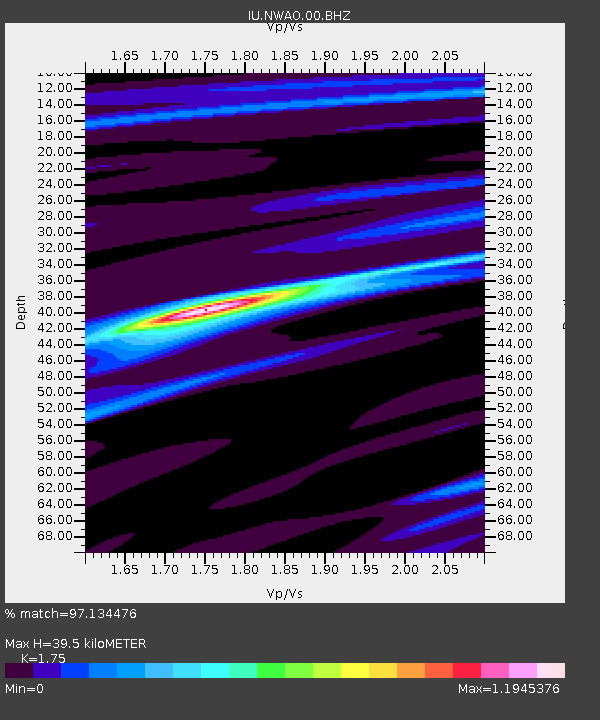
| Estimated Moho Depth: |
39.5 km |
| Estimated Crust Vp/Vs: |
1.75 |
| Assumed Crust Vp: |
6.419 km/s |
| Estimated Crust Vs: |
3.668 km/s |
| Estimated Crust Poisson's Ratio: |
0.26 |
|
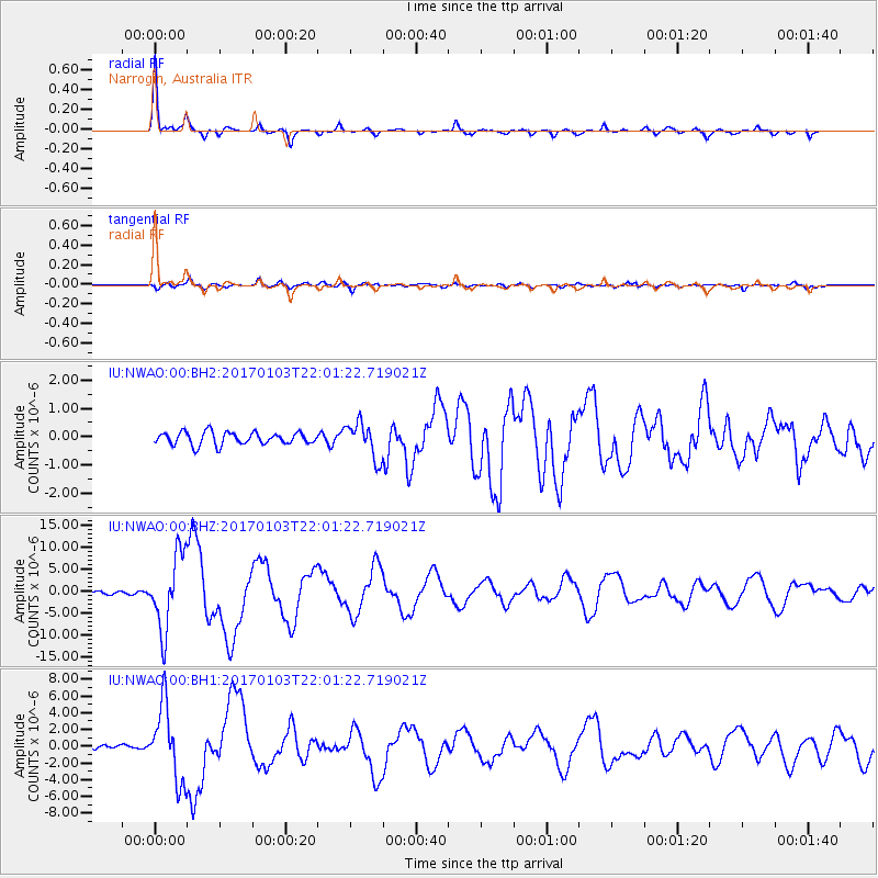
| Radial Match: |
97.134476 % |
| Radial Bump: |
305 |
| Transverse Match: |
91.12836 % |
| Transverse Bump: |
400 |
| SOD ConfigId: |
1943534 |
| Insert Time: |
2017-01-17 21:54:09.936 +0000 |
| GWidth: |
2.5 |
| Max Bumps: |
400 |
| Tol: |
0.001 |
|
Signal To Noise
| Channel | StoN | STA | LTA |
| IU:NWAO:00:BHZ:20170103T22:01:22.719021Z | 21.878307 | 8.500898E-6 | 3.885537E-7 |
| IU:NWAO:00:BH1:20170103T22:01:22.719021Z | 18.049002 | 4.3936784E-6 | 2.4343052E-7 |
| IU:NWAO:00:BH2:20170103T22:01:22.719021Z | 2.8516316 | 6.363436E-7 | 2.2315069E-7 |
| Arrivals |
| Ps | 4.9 SECOND |
| PpPs | 16 SECOND |
| PsPs/PpSs | 21 SECOND |


