You are here: Home > Network List > TA - USArray Transportable Network (new EarthScope stations) Stations List
> Station Q10A Clear Creek Ranch, Tonopah, NV, USA > Earthquake Result Viewer
Q10A Clear Creek Ranch, Tonopah, NV, USA - Earthquake Result Viewer
| Earthquake location: |
Guatemala |
| Earthquake latitude/longitude: |
14.4/-91.0 |
| Earthquake time(UTC): |
2007/07/23 (204) 22:30:08 GMT |
| Earthquake Depth: |
113 km |
| Earthquake Magnitude: |
5.5 MW, 5.3 MB, 5.5 MW |
| Earthquake Catalog/Contributor: |
WHDF/NEIC |
|
| Network: |
TA USArray Transportable Network (new EarthScope stations) |
| Station: |
Q10A Clear Creek Ranch, Tonopah, NV, USA |
| Lat/Lon: |
38.82 N/116.40 W |
| Elevation: |
2027 m |
|
| Distance: |
33.1 deg |
| Az: |
322.091 deg |
| Baz: |
130.338 deg |
| Ray Param: |
0.078031905 |
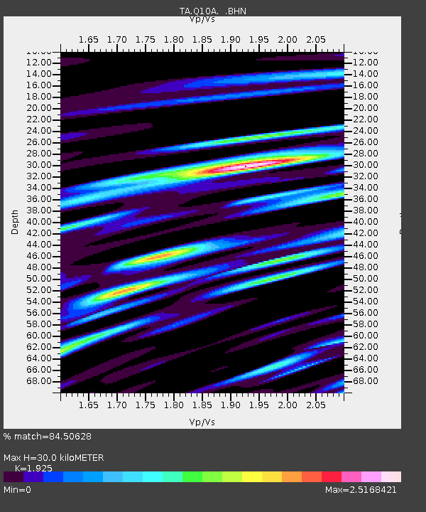
| Estimated Moho Depth: |
30.0 km |
| Estimated Crust Vp/Vs: |
1.92 |
| Assumed Crust Vp: |
6.276 km/s |
| Estimated Crust Vs: |
3.26 km/s |
| Estimated Crust Poisson's Ratio: |
0.32 |
|
| Radial Match: |
84.50628 % |
| Radial Bump: |
400 |
| Transverse Match: |
83.832 % |
| Transverse Bump: |
400 |
| SOD ConfigId: |
2564 |
| Insert Time: |
2010-03-07 03:14:12.194 +0000 |
| GWidth: |
2.5 |
| Max Bumps: |
400 |
| Tol: |
0.001 |
|

Signal To Noise
| Channel | StoN | STA | LTA |
| TA:Q10A: :BHN:20070723T22:36:03.400012Z | 6.0760884 | 5.483933E-7 | 9.025433E-8 |
| TA:Q10A: :BHE:20070723T22:36:03.400012Z | 5.0161514 | 5.4290814E-7 | 1.0823201E-7 |
| TA:Q10A: :BHZ:20070723T22:36:03.400012Z | 13.7601185 | 1.0347134E-6 | 7.5196546E-8 |
| Arrivals |
| Ps | 4.7 SECOND |
| PpPs | 13 SECOND |
| PsPs/PpSs | 18 SECOND |


