You are here: Home > Network List > TA - USArray Transportable Network (new EarthScope stations) Stations List
> Station F21K Alatna River, AK, USA > Earthquake Result Viewer
F21K Alatna River, AK, USA - Earthquake Result Viewer
| Earthquake location: |
Near Coast Of Chiapas, Mexico |
| Earthquake latitude/longitude: |
16.0/-93.7 |
| Earthquake time(UTC): |
2019/08/12 (224) 20:39:35 GMT |
| Earthquake Depth: |
92 km |
| Earthquake Magnitude: |
5.5 Mww |
| Earthquake Catalog/Contributor: |
NEIC PDE/us |
|
| Network: |
TA USArray Transportable Network (new EarthScope stations) |
| Station: |
F21K Alatna River, AK, USA |
| Lat/Lon: |
67.22 N/153.48 W |
| Elevation: |
597 m |
|
| Distance: |
63.9 deg |
| Az: |
337.989 deg |
| Baz: |
112.197 deg |
| Ray Param: |
0.05903342 |
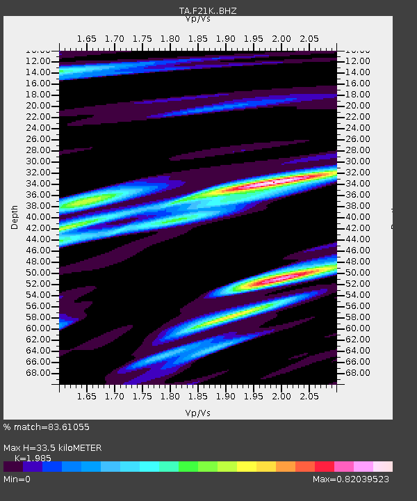
| Estimated Moho Depth: |
33.5 km |
| Estimated Crust Vp/Vs: |
1.99 |
| Assumed Crust Vp: |
6.455 km/s |
| Estimated Crust Vs: |
3.252 km/s |
| Estimated Crust Poisson's Ratio: |
0.33 |
|
| Radial Match: |
83.61055 % |
| Radial Bump: |
400 |
| Transverse Match: |
69.44806 % |
| Transverse Bump: |
400 |
| SOD ConfigId: |
19053131 |
| Insert Time: |
2019-08-26 20:45:22.711 +0000 |
| GWidth: |
2.5 |
| Max Bumps: |
400 |
| Tol: |
0.001 |
|
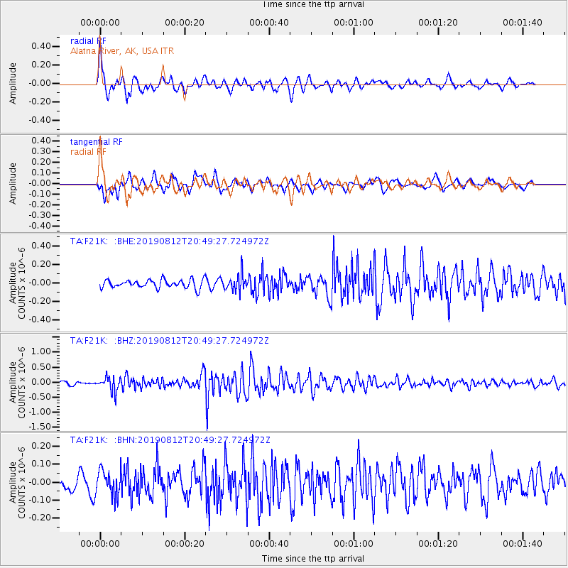
Signal To Noise
| Channel | StoN | STA | LTA |
| TA:F21K: :BHZ:20190812T20:49:27.724972Z | 4.110446 | 2.347769E-7 | 5.711714E-8 |
| TA:F21K: :BHN:20190812T20:49:27.724972Z | 2.2533195 | 7.1439594E-8 | 3.1704158E-8 |
| TA:F21K: :BHE:20190812T20:49:27.724972Z | 1.9013842 | 8.6727326E-8 | 4.5612726E-8 |
| Arrivals |
| Ps | 5.3 SECOND |
| PpPs | 15 SECOND |
| PsPs/PpSs | 20 SECOND |


