You are here: Home > Network List > TA - USArray Transportable Network (new EarthScope stations) Stations List
> Station I23K Minto, Yukon-Koyukuk, AK, USA > Earthquake Result Viewer
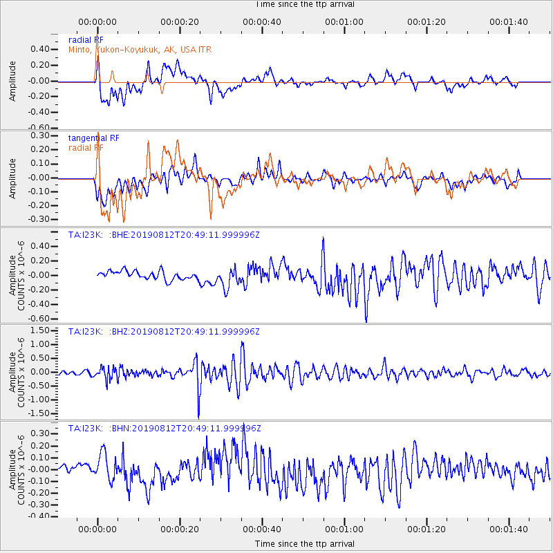
I23K Minto, Yukon-Koyukuk, AK, USA - Earthquake Result Viewer
*The percent match for this event was below the threshold and hence no stack was calculated.
| Earthquake location: |
Near Coast Of Chiapas, Mexico |
| Earthquake latitude/longitude: |
16.0/-93.7 |
| Earthquake time(UTC): |
2019/08/12 (224) 20:39:35 GMT |
| Earthquake Depth: |
92 km |
| Earthquake Magnitude: |
5.5 Mww |
| Earthquake Catalog/Contributor: |
NEIC PDE/us |
|
| Network: |
TA USArray Transportable Network (new EarthScope stations) |
| Station: |
I23K Minto, Yukon-Koyukuk, AK, USA |
| Lat/Lon: |
65.15 N/149.36 W |
| Elevation: |
149 m |
|
| Distance: |
61.5 deg |
| Az: |
336.604 deg |
| Baz: |
115.33 deg |
| Ray Param: |
$rayparam |
*The percent match for this event was below the threshold and hence was not used in the summary stack. |
|
| Radial Match: |
57.308525 % |
| Radial Bump: |
400 |
| Transverse Match: |
61.109795 % |
| Transverse Bump: |
400 |
| SOD ConfigId: |
19053131 |
| Insert Time: |
2019-08-26 20:45:36.394 +0000 |
| GWidth: |
2.5 |
| Max Bumps: |
400 |
| Tol: |
0.001 |
|
Signal To Noise
| Channel | StoN | STA | LTA |
| TA:I23K: :BHZ:20190812T20:49:11.999996Z | 3.6838136 | 2.0636713E-7 | 5.6019974E-8 |
| TA:I23K: :BHN:20190812T20:49:11.999996Z | 1.7374655 | 1.2373998E-7 | 7.1218665E-8 |
| TA:I23K: :BHE:20190812T20:49:11.999996Z | 2.3627734 | 1.3657659E-7 | 5.7803504E-8 |
| Arrivals |
| Ps | |
| PpPs | |
| PsPs/PpSs | |


