You are here: Home > Network List > TA - USArray Transportable Network (new EarthScope stations) Stations List
> Station P23K Montague Island, AK, USA > Earthquake Result Viewer
P23K Montague Island, AK, USA - Earthquake Result Viewer
| Earthquake location: |
Near Coast Of Chiapas, Mexico |
| Earthquake latitude/longitude: |
16.0/-93.7 |
| Earthquake time(UTC): |
2019/08/12 (224) 20:39:35 GMT |
| Earthquake Depth: |
92 km |
| Earthquake Magnitude: |
5.5 Mww |
| Earthquake Catalog/Contributor: |
NEIC PDE/us |
|
| Network: |
TA USArray Transportable Network (new EarthScope stations) |
| Station: |
P23K Montague Island, AK, USA |
| Lat/Lon: |
60.00 N/147.40 W |
| Elevation: |
287 m |
|
| Distance: |
58.5 deg |
| Az: |
331.635 deg |
| Baz: |
114.581 deg |
| Ray Param: |
0.062532574 |
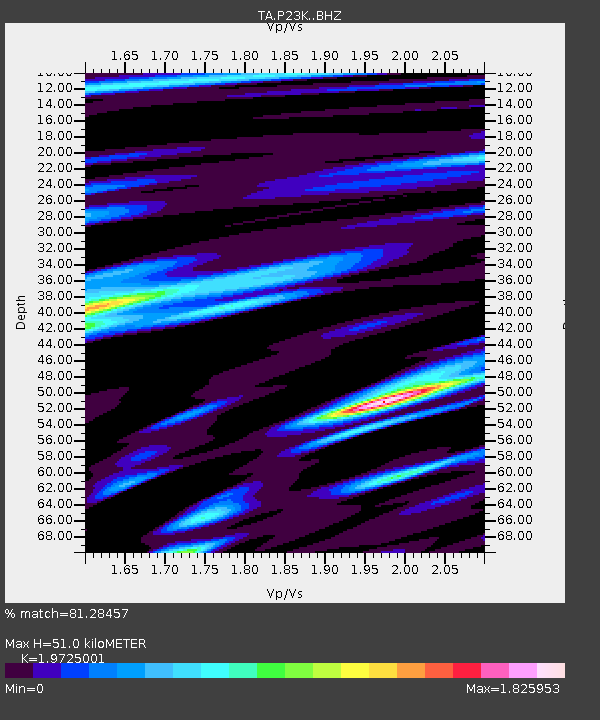
| Estimated Moho Depth: |
51.0 km |
| Estimated Crust Vp/Vs: |
1.97 |
| Assumed Crust Vp: |
5.989 km/s |
| Estimated Crust Vs: |
3.036 km/s |
| Estimated Crust Poisson's Ratio: |
0.33 |
|
| Radial Match: |
81.28457 % |
| Radial Bump: |
400 |
| Transverse Match: |
63.080173 % |
| Transverse Bump: |
400 |
| SOD ConfigId: |
19053131 |
| Insert Time: |
2019-08-26 20:46:00.299 +0000 |
| GWidth: |
2.5 |
| Max Bumps: |
400 |
| Tol: |
0.001 |
|

Signal To Noise
| Channel | StoN | STA | LTA |
| TA:P23K: :BHZ:20190812T20:48:51.499996Z | 2.7104552 | 2.0278458E-7 | 7.481569E-8 |
| TA:P23K: :BHN:20190812T20:48:51.499996Z | 0.91954297 | 7.991339E-8 | 8.690556E-8 |
| TA:P23K: :BHE:20190812T20:48:51.499996Z | 1.2504376 | 1.1174738E-7 | 8.936662E-8 |
| Arrivals |
| Ps | 8.6 SECOND |
| PpPs | 24 SECOND |
| PsPs/PpSs | 33 SECOND |


