You are here: Home > Network List > TA - USArray Transportable Network (new EarthScope stations) Stations List
> Station R33M Jennings River, BC, CAN > Earthquake Result Viewer
R33M Jennings River, BC, CAN - Earthquake Result Viewer
| Earthquake location: |
Near Coast Of Chiapas, Mexico |
| Earthquake latitude/longitude: |
16.0/-93.7 |
| Earthquake time(UTC): |
2019/08/12 (224) 20:39:35 GMT |
| Earthquake Depth: |
92 km |
| Earthquake Magnitude: |
5.5 Mww |
| Earthquake Catalog/Contributor: |
NEIC PDE/us |
|
| Network: |
TA USArray Transportable Network (new EarthScope stations) |
| Station: |
R33M Jennings River, BC, CAN |
| Lat/Lon: |
59.39 N/130.97 W |
| Elevation: |
1437 m |
|
| Distance: |
51.2 deg |
| Az: |
336.569 deg |
| Baz: |
131.619 deg |
| Ray Param: |
0.067268565 |
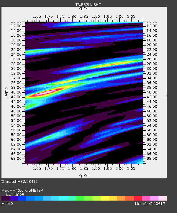
| Estimated Moho Depth: |
40.0 km |
| Estimated Crust Vp/Vs: |
1.68 |
| Assumed Crust Vp: |
6.597 km/s |
| Estimated Crust Vs: |
3.921 km/s |
| Estimated Crust Poisson's Ratio: |
0.23 |
|
| Radial Match: |
82.28411 % |
| Radial Bump: |
400 |
| Transverse Match: |
72.16958 % |
| Transverse Bump: |
400 |
| SOD ConfigId: |
19053131 |
| Insert Time: |
2019-08-26 20:46:06.247 +0000 |
| GWidth: |
2.5 |
| Max Bumps: |
400 |
| Tol: |
0.001 |
|
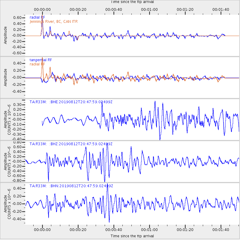
Signal To Noise
| Channel | StoN | STA | LTA |
| TA:R33M: :BHZ:20190812T20:47:59.02499Z | 4.3115835 | 2.3374194E-7 | 5.421255E-8 |
| TA:R33M: :BHN:20190812T20:47:59.02499Z | 3.087524 | 1.2954115E-7 | 4.1956323E-8 |
| TA:R33M: :BHE:20190812T20:47:59.02499Z | 2.7482235 | 1.2661054E-7 | 4.6069957E-8 |
| Arrivals |
| Ps | 4.4 SECOND |
| PpPs | 15 SECOND |
| PsPs/PpSs | 20 SECOND |


