You are here: Home > Network List > IU - Global Seismograph Network (GSN - IRIS/USGS) Stations List
> Station XMAS Kiritimati Island, Republic of Kiribati > Earthquake Result Viewer
XMAS Kiritimati Island, Republic of Kiribati - Earthquake Result Viewer
| Earthquake location: |
South Of Fiji Islands |
| Earthquake latitude/longitude: |
-19.3/176.1 |
| Earthquake time(UTC): |
2017/01/03 (003) 21:52:31 GMT |
| Earthquake Depth: |
17 km |
| Earthquake Magnitude: |
6.9 Mww |
| Earthquake Catalog/Contributor: |
NEIC PDE/us |
|
| Network: |
IU Global Seismograph Network (GSN - IRIS/USGS) |
| Station: |
XMAS Kiritimati Island, Republic of Kiribati |
| Lat/Lon: |
2.04 N/157.45 W |
| Elevation: |
20 m |
|
| Distance: |
33.6 deg |
| Az: |
53.691 deg |
| Baz: |
229.594 deg |
| Ray Param: |
0.07811793 |
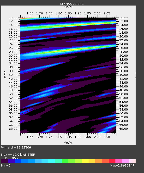
| Estimated Moho Depth: |
10.0 km |
| Estimated Crust Vp/Vs: |
1.61 |
| Assumed Crust Vp: |
4.802 km/s |
| Estimated Crust Vs: |
2.992 km/s |
| Estimated Crust Poisson's Ratio: |
0.18 |
|
| Radial Match: |
89.22506 % |
| Radial Bump: |
259 |
| Transverse Match: |
83.746346 % |
| Transverse Bump: |
383 |
| SOD ConfigId: |
1943534 |
| Insert Time: |
2017-01-17 21:54:29.278 +0000 |
| GWidth: |
2.5 |
| Max Bumps: |
400 |
| Tol: |
0.001 |
|
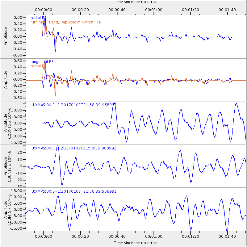
Signal To Noise
| Channel | StoN | STA | LTA |
| IU:XMAS:00:BHZ:20170103T21:58:39.96899Z | 3.0442436 | 4.0610394E-6 | 1.3340061E-6 |
| IU:XMAS:00:BH1:20170103T21:58:39.96899Z | 1.9589875 | 2.0411035E-6 | 1.0419176E-6 |
| IU:XMAS:00:BH2:20170103T21:58:39.96899Z | 0.76686597 | 1.1715397E-6 | 1.527698E-6 |
| Arrivals |
| Ps | 1.3 SECOND |
| PpPs | 5.2 SECOND |
| PsPs/PpSs | 6.5 SECOND |


