You are here: Home > Network List > US - United States National Seismic Network Stations List
> Station HAWA Hanford, Washington, USA > Earthquake Result Viewer
HAWA Hanford, Washington, USA - Earthquake Result Viewer

| Earthquake location: |
South Of Fiji Islands |
| Earthquake latitude/longitude: |
-19.3/176.1 |
| Earthquake time(UTC): |
2017/01/03 (003) 21:52:31 GMT |
| Earthquake Depth: |
17 km |
| Earthquake Magnitude: |
6.9 Mww |
| Earthquake Catalog/Contributor: |
NEIC PDE/us |
|
| Network: |
US United States National Seismic Network |
| Station: |
HAWA Hanford, Washington, USA |
| Lat/Lon: |
46.39 N/119.53 W |
| Elevation: |
364 m |
|
| Distance: |
87.4 deg |
| Az: |
38.675 deg |
| Baz: |
238.496 deg |
| Ray Param: |
0.043319054 |
| Estimated Moho Depth: |
12.0 km |
| Estimated Crust Vp/Vs: |
1.71 |
| Assumed Crust Vp: |
6.419 km/s |
| Estimated Crust Vs: |
3.759 km/s |
| Estimated Crust Poisson's Ratio: |
0.24 |
|
| Radial Match: |
92.33546 % |
| Radial Bump: |
400 |
| Transverse Match: |
85.03351 % |
| Transverse Bump: |
400 |
| SOD ConfigId: |
1943534 |
| Insert Time: |
2017-01-17 21:55:24.649 +0000 |
| GWidth: |
2.5 |
| Max Bumps: |
400 |
| Tol: |
0.001 |
|
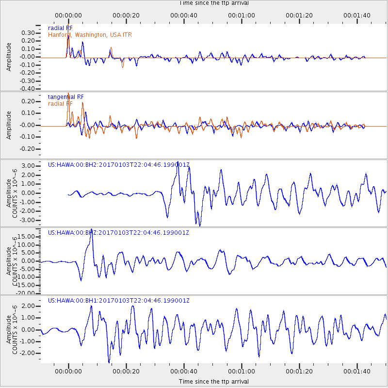
Signal To Noise
| Channel | StoN | STA | LTA |
| US:HAWA:00:BHZ:20170103T22:04:46.199001Z | 16.903072 | 4.487491E-6 | 2.6548375E-7 |
| US:HAWA:00:BH1:20170103T22:04:46.199001Z | 2.8732932 | 4.8717453E-7 | 1.6955268E-7 |
| US:HAWA:00:BH2:20170103T22:04:46.199001Z | 7.3525095 | 1.0405131E-6 | 1.4151809E-7 |
| Arrivals |
| Ps | 1.4 SECOND |
| PpPs | 4.9 SECOND |
| PsPs/PpSs | 6.3 SECOND |


