You are here: Home > Network List > TA - USArray Transportable Network (new EarthScope stations) Stations List
> Station N20K Mount Spurr, AK, USA > Earthquake Result Viewer
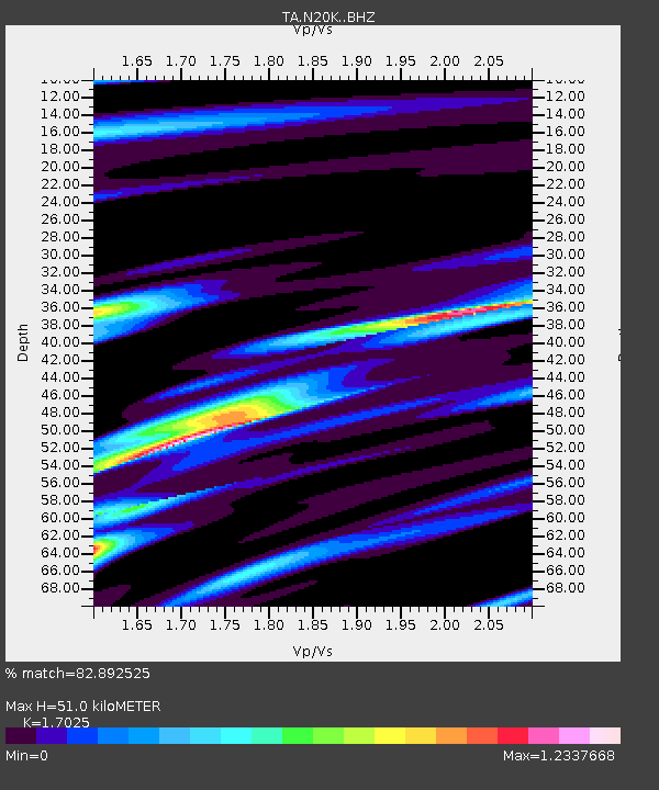
N20K Mount Spurr, AK, USA - Earthquake Result Viewer
| Earthquake location: |
Revilla Gigedo Islands Region |
| Earthquake latitude/longitude: |
20.5/-109.2 |
| Earthquake time(UTC): |
2019/08/14 (226) 21:35:19 GMT |
| Earthquake Depth: |
10 km |
| Earthquake Magnitude: |
5.8 Mww |
| Earthquake Catalog/Contributor: |
NEIC PDE/us |
|
| Network: |
TA USArray Transportable Network (new EarthScope stations) |
| Station: |
N20K Mount Spurr, AK, USA |
| Lat/Lon: |
61.20 N/152.21 W |
| Elevation: |
991 m |
|
| Distance: |
50.5 deg |
| Az: |
334.666 deg |
| Baz: |
124.053 deg |
| Ray Param: |
0.06803182 |
| Estimated Moho Depth: |
51.0 km |
| Estimated Crust Vp/Vs: |
1.70 |
| Assumed Crust Vp: |
6.566 km/s |
| Estimated Crust Vs: |
3.857 km/s |
| Estimated Crust Poisson's Ratio: |
0.24 |
|
| Radial Match: |
82.892525 % |
| Radial Bump: |
400 |
| Transverse Match: |
63.670303 % |
| Transverse Bump: |
400 |
| SOD ConfigId: |
19053131 |
| Insert Time: |
2019-08-28 21:44:20.921 +0000 |
| GWidth: |
2.5 |
| Max Bumps: |
400 |
| Tol: |
0.001 |
|

Signal To Noise
| Channel | StoN | STA | LTA |
| TA:N20K: :BHZ:20190814T21:43:46.649997Z | 3.2704647 | 2.2358333E-7 | 6.8364386E-8 |
| TA:N20K: :BHN:20190814T21:43:46.649997Z | 1.4375038 | 1.0399672E-7 | 7.234535E-8 |
| TA:N20K: :BHE:20190814T21:43:46.649997Z | 1.408393 | 9.16304E-8 | 6.506024E-8 |
| Arrivals |
| Ps | 5.8 SECOND |
| PpPs | 20 SECOND |
| PsPs/PpSs | 26 SECOND |


