You are here: Home > Network List > TA - USArray Transportable Network (new EarthScope stations) Stations List
> Station O18K Koktuh Hills, AK, USA > Earthquake Result Viewer
O18K Koktuh Hills, AK, USA - Earthquake Result Viewer
| Earthquake location: |
Revilla Gigedo Islands Region |
| Earthquake latitude/longitude: |
20.5/-109.2 |
| Earthquake time(UTC): |
2019/08/14 (226) 21:35:19 GMT |
| Earthquake Depth: |
10 km |
| Earthquake Magnitude: |
5.8 Mww |
| Earthquake Catalog/Contributor: |
NEIC PDE/us |
|
| Network: |
TA USArray Transportable Network (new EarthScope stations) |
| Station: |
O18K Koktuh Hills, AK, USA |
| Lat/Lon: |
59.85 N/155.21 W |
| Elevation: |
544 m |
|
| Distance: |
51.0 deg |
| Az: |
332.173 deg |
| Baz: |
119.869 deg |
| Ray Param: |
0.067675285 |
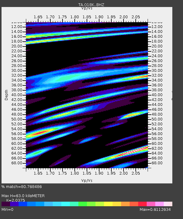
| Estimated Moho Depth: |
63.0 km |
| Estimated Crust Vp/Vs: |
2.04 |
| Assumed Crust Vp: |
6.438 km/s |
| Estimated Crust Vs: |
3.16 km/s |
| Estimated Crust Poisson's Ratio: |
0.34 |
|
| Radial Match: |
80.768486 % |
| Radial Bump: |
400 |
| Transverse Match: |
57.71337 % |
| Transverse Bump: |
400 |
| SOD ConfigId: |
19053131 |
| Insert Time: |
2019-08-28 21:44:24.074 +0000 |
| GWidth: |
2.5 |
| Max Bumps: |
400 |
| Tol: |
0.001 |
|

Signal To Noise
| Channel | StoN | STA | LTA |
| TA:O18K: :BHZ:20190814T21:43:50.750003Z | 2.9067745 | 2.4462562E-7 | 8.4157065E-8 |
| TA:O18K: :BHN:20190814T21:43:50.750003Z | 1.4830445 | 1.16602216E-7 | 7.862354E-8 |
| TA:O18K: :BHE:20190814T21:43:50.750003Z | 2.0020924 | 1.5558561E-7 | 7.7711505E-8 |
| Arrivals |
| Ps | 11 SECOND |
| PpPs | 28 SECOND |
| PsPs/PpSs | 39 SECOND |


