You are here: Home > Network List > US - United States National Seismic Network Stations List
> Station WMOK Wichita Mountains, Oklahoma, USA > Earthquake Result Viewer
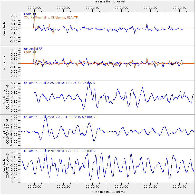
WMOK Wichita Mountains, Oklahoma, USA - Earthquake Result Viewer
*The percent match for this event was below the threshold and hence no stack was calculated.
| Earthquake location: |
South Of Fiji Islands |
| Earthquake latitude/longitude: |
-19.3/176.1 |
| Earthquake time(UTC): |
2017/01/03 (003) 21:52:31 GMT |
| Earthquake Depth: |
17 km |
| Earthquake Magnitude: |
6.9 Mww |
| Earthquake Catalog/Contributor: |
NEIC PDE/us |
|
| Network: |
US United States National Seismic Network |
| Station: |
WMOK Wichita Mountains, Oklahoma, USA |
| Lat/Lon: |
34.74 N/98.78 W |
| Elevation: |
486 m |
|
| Distance: |
97.0 deg |
| Az: |
55.762 deg |
| Baz: |
251.434 deg |
| Ray Param: |
$rayparam |
*The percent match for this event was below the threshold and hence was not used in the summary stack. |
|
| Radial Match: |
79.7182 % |
| Radial Bump: |
400 |
| Transverse Match: |
66.879555 % |
| Transverse Bump: |
400 |
| SOD ConfigId: |
1943534 |
| Insert Time: |
2017-01-17 21:56:07.258 +0000 |
| GWidth: |
2.5 |
| Max Bumps: |
400 |
| Tol: |
0.001 |
|
Signal To Noise
| Channel | StoN | STA | LTA |
| US:WMOK:00:BHZ:20170103T22:05:30.074001Z | 8.334161 | 1.1080031E-6 | 1.3294716E-7 |
| US:WMOK:00:BH1:20170103T22:05:30.074001Z | 1.8274988 | 2.5586021E-7 | 1.4000568E-7 |
| US:WMOK:00:BH2:20170103T22:05:30.074001Z | 2.3001876 | 3.9097156E-7 | 1.6997379E-7 |
| Arrivals |
| Ps | |
| PpPs | |
| PsPs/PpSs | |


