You are here: Home > Network List > TA - USArray Transportable Network (new EarthScope stations) Stations List
> Station M12A Wells, NV, USA > Earthquake Result Viewer
M12A Wells, NV, USA - Earthquake Result Viewer
| Earthquake location: |
South Of Fiji Islands |
| Earthquake latitude/longitude: |
-26.0/-177.5 |
| Earthquake time(UTC): |
2007/12/09 (343) 07:28:20 GMT |
| Earthquake Depth: |
152 km |
| Earthquake Magnitude: |
7.0 MB, 7.8 MW, 7.7 MW |
| Earthquake Catalog/Contributor: |
WHDF/NEIC |
|
| Network: |
TA USArray Transportable Network (new EarthScope stations) |
| Station: |
M12A Wells, NV, USA |
| Lat/Lon: |
41.42 N/114.92 W |
| Elevation: |
1930 m |
|
| Distance: |
88.6 deg |
| Az: |
41.908 deg |
| Baz: |
233.058 deg |
| Ray Param: |
0.042120904 |
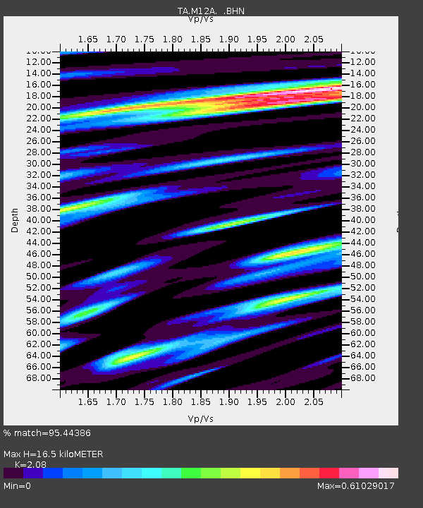
| Estimated Moho Depth: |
16.5 km |
| Estimated Crust Vp/Vs: |
2.08 |
| Assumed Crust Vp: |
6.276 km/s |
| Estimated Crust Vs: |
3.017 km/s |
| Estimated Crust Poisson's Ratio: |
0.35 |
|
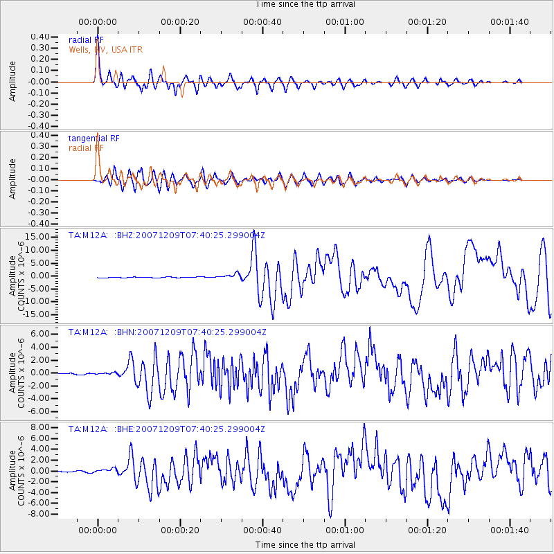
| Radial Match: |
95.44386 % |
| Radial Bump: |
378 |
| Transverse Match: |
89.175835 % |
| Transverse Bump: |
400 |
| SOD ConfigId: |
2564 |
| Insert Time: |
2010-03-07 03:17:00.325 +0000 |
| GWidth: |
2.5 |
| Max Bumps: |
400 |
| Tol: |
0.001 |
|
Signal To Noise
| Channel | StoN | STA | LTA |
| TA:M12A: :BHN:20071209T07:40:25.299004Z | 1.3795476 | 1.4112081E-7 | 1.0229499E-7 |
| TA:M12A: :BHE:20071209T07:40:25.299004Z | 5.080599 | 4.3507853E-7 | 8.5635286E-8 |
| TA:M12A: :BHZ:20071209T07:40:25.299004Z | 7.7147107 | 1.0462809E-6 | 1.3562153E-7 |
| Arrivals |
| Ps | 2.9 SECOND |
| PpPs | 8.0 SECOND |
| PsPs/PpSs | 11 SECOND |


