You are here: Home > Network List > TS - TERRAscope (Southern California Seismic Network) Stations List
> Station MLAC Mammoth Lakes, California, USA > Earthquake Result Viewer
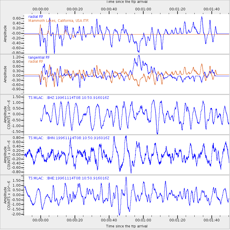
MLAC Mammoth Lakes, California, USA - Earthquake Result Viewer
*The percent match for this event was below the threshold and hence no stack was calculated.
| Earthquake location: |
Santa Cruz Islands |
| Earthquake latitude/longitude: |
-11.4/166.5 |
| Earthquake time(UTC): |
1996/11/14 (319) 07:58:58 GMT |
| Earthquake Depth: |
109 km |
| Earthquake Magnitude: |
5.7 MB |
| Earthquake Catalog/Contributor: |
WHDF/NEIC |
|
| Network: |
TS TERRAscope (Southern California Seismic Network) |
| Station: |
MLAC Mammoth Lakes, California, USA |
| Lat/Lon: |
37.63 N/118.83 W |
| Elevation: |
2170 m |
|
| Distance: |
85.1 deg |
| Az: |
50.235 deg |
| Baz: |
251.691 deg |
| Ray Param: |
$rayparam |
*The percent match for this event was below the threshold and hence was not used in the summary stack. |
|
| Radial Match: |
48.483246 % |
| Radial Bump: |
400 |
| Transverse Match: |
51.655426 % |
| Transverse Bump: |
400 |
| SOD ConfigId: |
4480 |
| Insert Time: |
2010-02-26 14:25:40.358 +0000 |
| GWidth: |
2.5 |
| Max Bumps: |
400 |
| Tol: |
0.001 |
|
Signal To Noise
| Channel | StoN | STA | LTA |
| TS:MLAC: :BHN:19961114T08:10:50.916016Z | 1.0779457 | 1.9987733E-7 | 1.8542431E-7 |
| TS:MLAC: :BHE:19961114T08:10:50.916016Z | 1.6023608 | 1.065376E-6 | 6.6487894E-7 |
| TS:MLAC: :BHZ:19961114T08:10:50.916016Z | 1.2775241 | 8.2447406E-7 | 6.4536863E-7 |
| Arrivals |
| Ps | |
| PpPs | |
| PsPs/PpSs | |


