You are here: Home > Network List > UU - University of Utah Regional Network Stations List
> Station BSUT Blindstream Canyon, Hanna, UT, USA > Earthquake Result Viewer
BSUT Blindstream Canyon, Hanna, UT, USA - Earthquake Result Viewer
| Earthquake location: |
South Of Fiji Islands |
| Earthquake latitude/longitude: |
-19.3/176.1 |
| Earthquake time(UTC): |
2017/01/03 (003) 21:52:31 GMT |
| Earthquake Depth: |
17 km |
| Earthquake Magnitude: |
6.9 Mww |
| Earthquake Catalog/Contributor: |
NEIC PDE/us |
|
| Network: |
UU University of Utah Regional Network |
| Station: |
BSUT Blindstream Canyon, Hanna, UT, USA |
| Lat/Lon: |
40.54 N/110.76 W |
| Elevation: |
3211 m |
|
| Distance: |
90.3 deg |
| Az: |
46.85 deg |
| Baz: |
244.687 deg |
| Ray Param: |
0.041683912 |
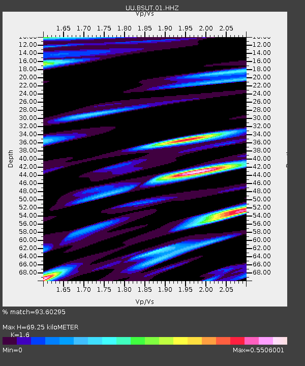
| Estimated Moho Depth: |
69.25 km |
| Estimated Crust Vp/Vs: |
1.60 |
| Assumed Crust Vp: |
6.155 km/s |
| Estimated Crust Vs: |
3.847 km/s |
| Estimated Crust Poisson's Ratio: |
0.18 |
|
| Radial Match: |
93.60295 % |
| Radial Bump: |
400 |
| Transverse Match: |
88.72389 % |
| Transverse Bump: |
400 |
| SOD ConfigId: |
1943534 |
| Insert Time: |
2017-01-17 21:56:18.089 +0000 |
| GWidth: |
2.5 |
| Max Bumps: |
400 |
| Tol: |
0.001 |
|

Signal To Noise
| Channel | StoN | STA | LTA |
| UU:BSUT:01:HHZ:20170103T22:04:59.55801Z | 7.4287796 | 4.9570975E-8 | 6.672829E-9 |
| UU:BSUT:01:HHN:20170103T22:04:59.55801Z | 1.0876 | 4.3150306E-9 | 3.9674792E-9 |
| UU:BSUT:01:HHE:20170103T22:04:59.55801Z | 1.5211589 | 1.2095592E-8 | 7.951564E-9 |
| Arrivals |
| Ps | 6.9 SECOND |
| PpPs | 29 SECOND |
| PsPs/PpSs | 36 SECOND |


