You are here: Home > Network List > TA - USArray Transportable Network (new EarthScope stations) Stations List
> Station M12A Wells, NV, USA > Earthquake Result Viewer
M12A Wells, NV, USA - Earthquake Result Viewer
| Earthquake location: |
Andreanof Islands, Aleutian Is. |
| Earthquake latitude/longitude: |
50.2/-177.6 |
| Earthquake time(UTC): |
2007/08/16 (228) 04:03:03 GMT |
| Earthquake Depth: |
15 km |
| Earthquake Magnitude: |
5.8 MB |
| Earthquake Catalog/Contributor: |
WHDF/NEIC |
|
| Network: |
TA USArray Transportable Network (new EarthScope stations) |
| Station: |
M12A Wells, NV, USA |
| Lat/Lon: |
41.42 N/114.92 W |
| Elevation: |
1930 m |
|
| Distance: |
43.4 deg |
| Az: |
76.674 deg |
| Baz: |
303.831 deg |
| Ray Param: |
0.0725914 |
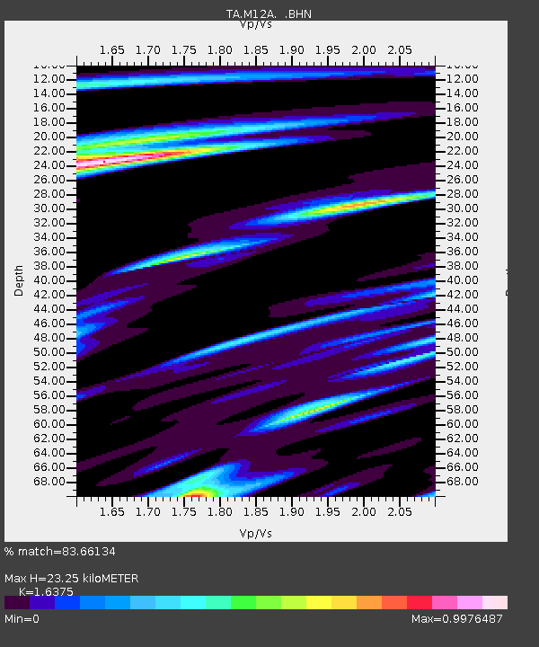
| Estimated Moho Depth: |
23.25 km |
| Estimated Crust Vp/Vs: |
1.64 |
| Assumed Crust Vp: |
6.276 km/s |
| Estimated Crust Vs: |
3.833 km/s |
| Estimated Crust Poisson's Ratio: |
0.20 |
|
| Radial Match: |
83.66134 % |
| Radial Bump: |
400 |
| Transverse Match: |
62.461124 % |
| Transverse Bump: |
400 |
| SOD ConfigId: |
2564 |
| Insert Time: |
2010-03-07 03:17:09.585 +0000 |
| GWidth: |
2.5 |
| Max Bumps: |
400 |
| Tol: |
0.001 |
|

Signal To Noise
| Channel | StoN | STA | LTA |
| TA:M12A: :BHN:20070816T04:10:34.200012Z | 1.9219121 | 3.633022E-7 | 1.8903165E-7 |
| TA:M12A: :BHE:20070816T04:10:34.200012Z | 2.9309375 | 4.877488E-7 | 1.6641393E-7 |
| TA:M12A: :BHZ:20070816T04:10:34.200012Z | 5.1163607 | 1.0020351E-6 | 1.958492E-7 |
| Arrivals |
| Ps | 2.5 SECOND |
| PpPs | 9.1 SECOND |
| PsPs/PpSs | 12 SECOND |


