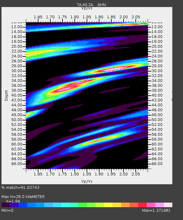
M12A Wells, NV, USA - Earthquake Result Viewer
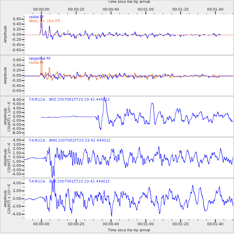
Earthquake location: Andreanof Islands, Aleutian Is.
Earthquake latitude/longitude: 50.3/-177.5
Earthquake time(UTC): 2007/08/15 (227) 20:22:11 GMT
Earthquake Depth: 9.0 km
Earthquake Magnitude: 6.3 MB, 6.2 MS, 6.4 MW, 5.9 ML
Earthquake Catalog/Contributor: WHDF/NEIC
Network: TA USArray Transportable Network (new EarthScope stations)
Station: M12A Wells, NV, USA
Lat/Lon: 41.42 N/114.92 W
Elevation: 1930 m
Distance: 43.3 deg
Az: 76.768 deg
Baz: 303.939 deg
Ray Param: 0.07262618
Estimated Moho Depth: 29.0 km
Estimated Crust Vp/Vs: 1.96
Assumed Crust Vp: 6.276 km/s
Estimated Crust Vs: 3.202 km/s
Estimated Crust Poisson's Ratio: 0.32
Radial Match: 91.82743 %
Radial Bump: 400
Transverse Match: 78.092186 %
Transverse Bump: 400
SOD ConfigId: 2564
Insert Time: 2010-03-07 03:17:14.961 +0000
GWidth: 2.5
Max Bumps: 400
Tol: 0.001

Signal To Noise

ChannelStoNSTALTA
TA:M12A: :BHN:20070815T20:29:42.44901Z4.31912148.322902E-71.9269896E-7
TA:M12A: :BHE:20070815T20:29:42.44901Z4.2591081.2792744E-63.0036207E-7
TA:M12A: :BHZ:20070815T20:29:42.44901Z14.5658642.5955537E-61.781943E-7
Arrivals
Ps4.7 SECOND
PpPs13 SECOND
PsPs/PpSs18 SECOND