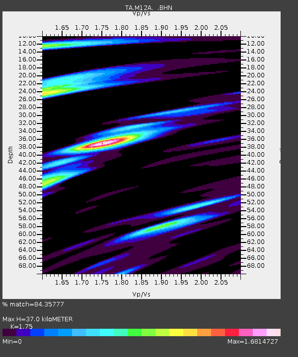
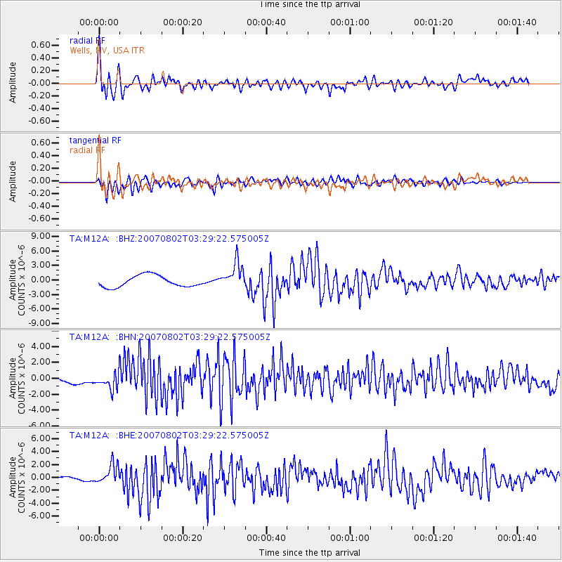
M12A Wells, NV, USA - Earthquake Result Viewer

Earthquake location: Andreanof Islands, Aleutian Is.
Earthquake latitude/longitude: 51.3/-180.0
Earthquake time(UTC): 2007/08/02 (214) 03:21:42 GMT
Earthquake Depth: 21 km
Earthquake Magnitude: 6.3 MB, 6.6 MS, 6.7 MW, 6.6 MW
Earthquake Catalog/Contributor: WHDF/NEIC
Network: TA USArray Transportable Network (new EarthScope stations)
Station: M12A Wells, NV, USA
Lat/Lon: 41.42 N/114.92 W
Elevation: 1930 m
Distance: 44.6 deg
Az: 76.261 deg
Baz: 305.837 deg
Ray Param: 0.07179308
Estimated Moho Depth: 37.0 km
Estimated Crust Vp/Vs: 1.75
Assumed Crust Vp: 6.276 km/s
Estimated Crust Vs: 3.586 km/s
Estimated Crust Poisson's Ratio: 0.26
Radial Match: 84.35777 %
Radial Bump: 400
Transverse Match: 77.95924 %
Transverse Bump: 400
SOD ConfigId: 2564
Insert Time: 2010-03-07 03:17:22.254 +0000
GWidth: 2.5
Max Bumps: 400
Tol: 0.001

Signal To Noise

ChannelStoNSTALTA
TA:M12A: :BHN:20070802T03:29:22.575005Z1.27930391.0904273E-68.5235985E-7
TA:M12A: :BHE:20070802T03:29:22.575005Z6.82009121.5093758E-62.2131314E-7
TA:M12A: :BHZ:20070802T03:29:22.575005Z2.38321382.8203895E-61.1834395E-6
Arrivals
Ps4.7 SECOND
PpPs15 SECOND
PsPs/PpSs20 SECOND