You are here: Home > Network List > TA - USArray Transportable Network (new EarthScope stations) Stations List
> Station M12A Wells, NV, USA > Earthquake Result Viewer
M12A Wells, NV, USA - Earthquake Result Viewer
| Earthquake location: |
Sakhalin, Russia |
| Earthquake latitude/longitude: |
47.1/141.8 |
| Earthquake time(UTC): |
2007/08/02 (214) 02:37:42 GMT |
| Earthquake Depth: |
5.0 km |
| Earthquake Magnitude: |
6.2 MS, 5.3 MB, 6.2 MW, 6.2 MW |
| Earthquake Catalog/Contributor: |
WHDF/NEIC |
|
| Network: |
TA USArray Transportable Network (new EarthScope stations) |
| Station: |
M12A Wells, NV, USA |
| Lat/Lon: |
41.42 N/114.92 W |
| Elevation: |
1930 m |
|
| Distance: |
68.7 deg |
| Az: |
51.784 deg |
| Baz: |
314.485 deg |
| Ray Param: |
0.056145348 |
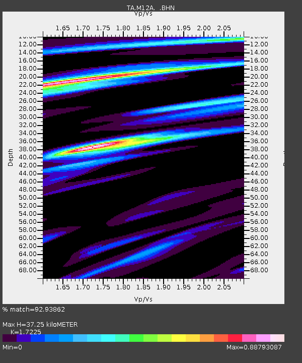
| Estimated Moho Depth: |
37.25 km |
| Estimated Crust Vp/Vs: |
1.72 |
| Assumed Crust Vp: |
6.276 km/s |
| Estimated Crust Vs: |
3.643 km/s |
| Estimated Crust Poisson's Ratio: |
0.25 |
|
| Radial Match: |
92.93862 % |
| Radial Bump: |
320 |
| Transverse Match: |
81.33477 % |
| Transverse Bump: |
400 |
| SOD ConfigId: |
2564 |
| Insert Time: |
2010-03-07 03:17:23.656 +0000 |
| GWidth: |
2.5 |
| Max Bumps: |
400 |
| Tol: |
0.001 |
|
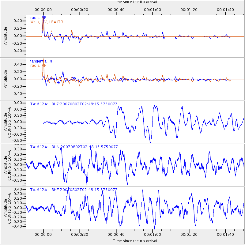
Signal To Noise
| Channel | StoN | STA | LTA |
| TA:M12A: :BHN:20070802T02:48:15.575007Z | 1.4834689 | 4.993561E-8 | 3.3661383E-8 |
| TA:M12A: :BHE:20070802T02:48:15.575007Z | 0.92314655 | 3.666754E-8 | 3.9720174E-8 |
| TA:M12A: :BHZ:20070802T02:48:15.575007Z | 2.6972506 | 1.1325701E-7 | 4.1989797E-8 |
| Arrivals |
| Ps | 4.5 SECOND |
| PpPs | 16 SECOND |
| PsPs/PpSs | 20 SECOND |


