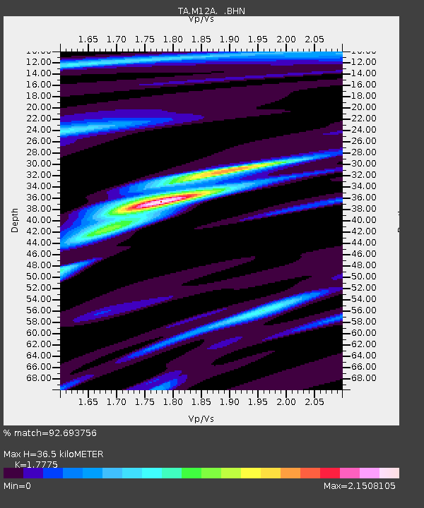
M12A Wells, NV, USA - Earthquake Result Viewer
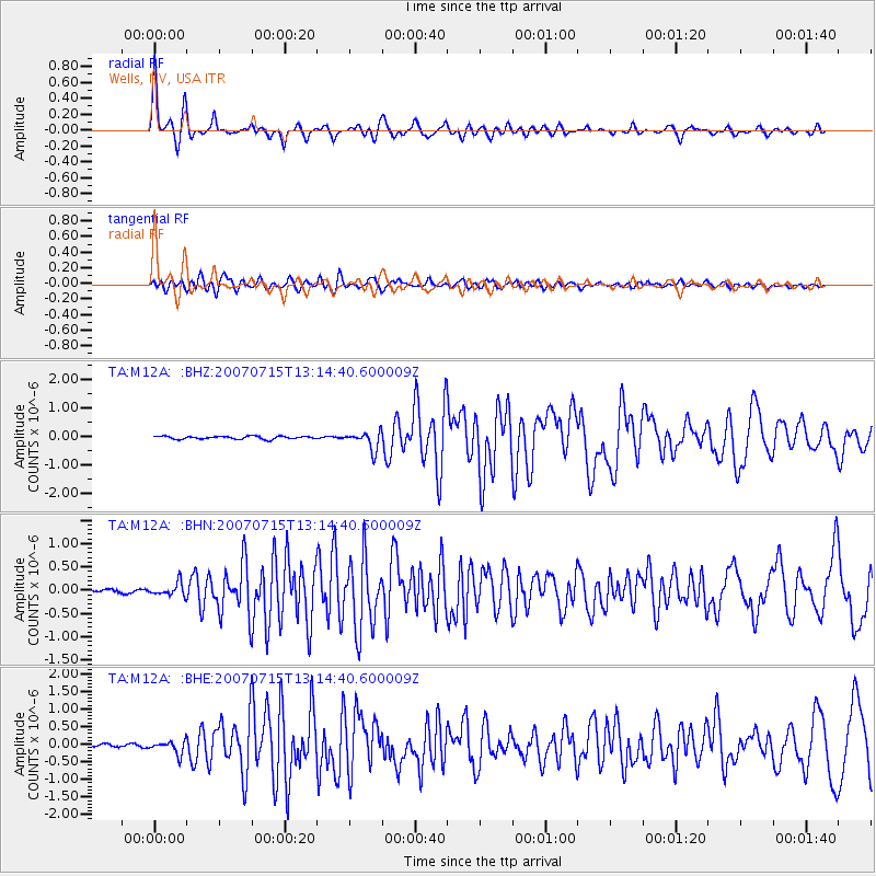
Earthquake location: Fox Islands, Aleutian Islands
Earthquake latitude/longitude: 52.5/-168.0
Earthquake time(UTC): 2007/07/15 (196) 13:08:00 GMT
Earthquake Depth: 10 km
Earthquake Magnitude: 5.8 MB, 5.9 MS, 6.1 MW, 6.0 MW
Earthquake Catalog/Contributor: WHDF/NEIC
Network: TA USArray Transportable Network (new EarthScope stations)
Station: M12A Wells, NV, USA
Lat/Lon: 41.42 N/114.92 W
Elevation: 1930 m
Distance: 37.1 deg
Az: 85.623 deg
Baz: 305.824 deg
Ray Param: 0.07630946
Estimated Moho Depth: 36.5 km
Estimated Crust Vp/Vs: 1.78
Assumed Crust Vp: 6.276 km/s
Estimated Crust Vs: 3.531 km/s
Estimated Crust Poisson's Ratio: 0.27
Radial Match: 92.693756 %
Radial Bump: 310
Transverse Match: 83.57903 %
Transverse Bump: 400
SOD ConfigId: 2564
Insert Time: 2010-03-07 03:17:37.388 +0000
GWidth: 2.5
Max Bumps: 400
Tol: 0.001

Signal To Noise

ChannelStoNSTALTA
TA:M12A: :BHN:20070715T13:14:40.600009Z3.9848841.3700385E-73.4380886E-8
TA:M12A: :BHE:20070715T13:14:40.600009Z4.11811161.7986294E-74.3676074E-8
TA:M12A: :BHZ:20070715T13:14:40.600009Z6.07374433.1669748E-75.214205E-8
Arrivals
Ps4.8 SECOND
PpPs15 SECOND
PsPs/PpSs20 SECOND