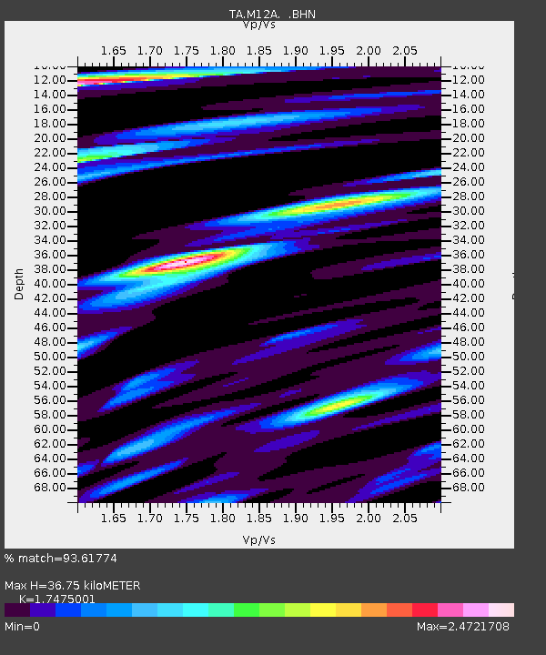
M12A Wells, NV, USA - Earthquake Result Viewer
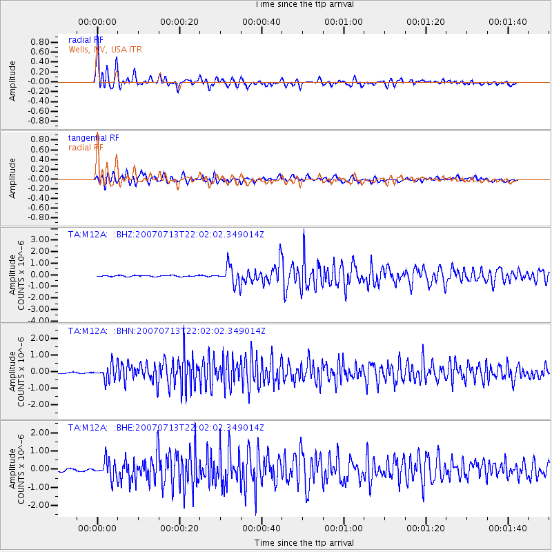
Earthquake location: Andreanof Islands, Aleutian Is.
Earthquake latitude/longitude: 51.8/-176.3
Earthquake time(UTC): 2007/07/13 (194) 21:54:43 GMT
Earthquake Depth: 35 km
Earthquake Magnitude: 5.7 MB, 5.6 MS, 6.0 MW, 5.9 MW
Earthquake Catalog/Contributor: WHDF/NEIC
Network: TA USArray Transportable Network (new EarthScope stations)
Station: M12A Wells, NV, USA
Lat/Lon: 41.42 N/114.92 W
Elevation: 1930 m
Distance: 42.2 deg
Az: 79.176 deg
Baz: 305.88 deg
Ray Param: 0.073228195
Estimated Moho Depth: 36.75 km
Estimated Crust Vp/Vs: 1.75
Assumed Crust Vp: 6.276 km/s
Estimated Crust Vs: 3.591 km/s
Estimated Crust Poisson's Ratio: 0.26
Radial Match: 93.61774 %
Radial Bump: 400
Transverse Match: 88.04246 %
Transverse Bump: 400
SOD ConfigId: 2564
Insert Time: 2010-03-07 03:17:38.784 +0000
GWidth: 2.5
Max Bumps: 400
Tol: 0.001

Signal To Noise

ChannelStoNSTALTA
TA:M12A: :BHN:20070713T22:02:02.349014Z7.50852734.485396E-75.973736E-8
TA:M12A: :BHE:20070713T22:02:02.349014Z5.8174.818142E-78.282864E-8
TA:M12A: :BHZ:20070713T22:02:02.349014Z17.5739358.111205E-74.6154746E-8
Arrivals
Ps4.7 SECOND
PpPs15 SECOND
PsPs/PpSs20 SECOND