You are here: Home > Network List > TA - USArray Transportable Network (new EarthScope stations) Stations List
> Station M12A Wells, NV, USA > Earthquake Result Viewer
M12A Wells, NV, USA - Earthquake Result Viewer
| Earthquake location: |
Tonga Islands |
| Earthquake latitude/longitude: |
-20.6/-175.6 |
| Earthquake time(UTC): |
2007/02/05 (036) 09:55:51 GMT |
| Earthquake Depth: |
10 km |
| Earthquake Magnitude: |
5.7 MB, 5.6 MS, 5.7 MW, 5.7 MW |
| Earthquake Catalog/Contributor: |
WHDF/NEIC |
|
| Network: |
TA USArray Transportable Network (new EarthScope stations) |
| Station: |
M12A Wells, NV, USA |
| Lat/Lon: |
41.42 N/114.92 W |
| Elevation: |
1930 m |
|
| Distance: |
83.5 deg |
| Az: |
41.332 deg |
| Baz: |
235.342 deg |
| Ray Param: |
0.046169974 |
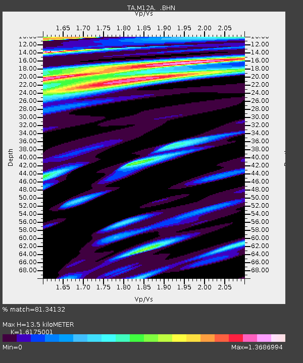
| Estimated Moho Depth: |
13.5 km |
| Estimated Crust Vp/Vs: |
1.62 |
| Assumed Crust Vp: |
6.276 km/s |
| Estimated Crust Vs: |
3.88 km/s |
| Estimated Crust Poisson's Ratio: |
0.19 |
|
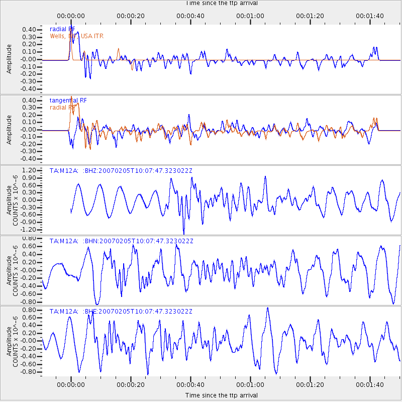
| Radial Match: |
81.34132 % |
| Radial Bump: |
400 |
| Transverse Match: |
71.04511 % |
| Transverse Bump: |
400 |
| SOD ConfigId: |
2564 |
| Insert Time: |
2010-03-07 03:17:51.680 +0000 |
| GWidth: |
2.5 |
| Max Bumps: |
400 |
| Tol: |
0.001 |
|
Signal To Noise
| Channel | StoN | STA | LTA |
| TA:M12A: :BHN:20070205T10:07:47.323022Z | 0.4402192 | 1.62493E-7 | 3.6911837E-7 |
| TA:M12A: :BHE:20070205T10:07:47.323022Z | 2.6250641 | 4.883451E-7 | 1.8603168E-7 |
| TA:M12A: :BHZ:20070205T10:07:47.323022Z | 1.1901315 | 4.7824307E-7 | 4.0184048E-7 |
| Arrivals |
| Ps | 1.4 SECOND |
| PpPs | 5.5 SECOND |
| PsPs/PpSs | 6.8 SECOND |


