You are here: Home > Network List > TA - USArray Transportable Network (new EarthScope stations) Stations List
> Station A19K Wainwright, AK, USA > Earthquake Result Viewer
A19K Wainwright, AK, USA - Earthquake Result Viewer
| Earthquake location: |
Mariana Islands |
| Earthquake latitude/longitude: |
16.6/146.4 |
| Earthquake time(UTC): |
2019/08/18 (230) 18:00:29 GMT |
| Earthquake Depth: |
34 km |
| Earthquake Magnitude: |
5.9 Mi |
| Earthquake Catalog/Contributor: |
NEIC PDE/pt |
|
| Network: |
TA USArray Transportable Network (new EarthScope stations) |
| Station: |
A19K Wainwright, AK, USA |
| Lat/Lon: |
70.20 N/161.07 W |
| Elevation: |
24 m |
|
| Distance: |
62.3 deg |
| Az: |
17.781 deg |
| Baz: |
239.272 deg |
| Ray Param: |
0.060285993 |
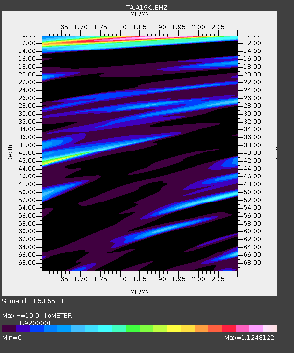
| Estimated Moho Depth: |
10.0 km |
| Estimated Crust Vp/Vs: |
1.92 |
| Assumed Crust Vp: |
5.989 km/s |
| Estimated Crust Vs: |
3.119 km/s |
| Estimated Crust Poisson's Ratio: |
0.31 |
|
| Radial Match: |
85.85513 % |
| Radial Bump: |
400 |
| Transverse Match: |
79.54497 % |
| Transverse Bump: |
400 |
| SOD ConfigId: |
19053131 |
| Insert Time: |
2019-09-01 18:10:36.813 +0000 |
| GWidth: |
2.5 |
| Max Bumps: |
400 |
| Tol: |
0.001 |
|

Signal To Noise
| Channel | StoN | STA | LTA |
| TA:A19K: :BHZ:20190818T18:10:16.825012Z | 11.548097 | 1.6606613E-6 | 1.438039E-7 |
| TA:A19K: :BHN:20190818T18:10:16.825012Z | 3.3044288 | 3.0876336E-7 | 9.3439255E-8 |
| TA:A19K: :BHE:20190818T18:10:16.825012Z | 2.7630382 | 4.0628134E-7 | 1.4704152E-7 |
| Arrivals |
| Ps | 1.6 SECOND |
| PpPs | 4.7 SECOND |
| PsPs/PpSs | 6.3 SECOND |


