You are here: Home > Network List > TA - USArray Transportable Network (new EarthScope stations) Stations List
> Station M12A Wells, NV, USA > Earthquake Result Viewer
M12A Wells, NV, USA - Earthquake Result Viewer
| Earthquake location: |
Mariana Islands |
| Earthquake latitude/longitude: |
18.9/145.4 |
| Earthquake time(UTC): |
2007/10/31 (304) 03:30:17 GMT |
| Earthquake Depth: |
223 km |
| Earthquake Magnitude: |
6.2 MB, 7.2 MW, 7.2 MW |
| Earthquake Catalog/Contributor: |
WHDF/NEIC |
|
| Network: |
TA USArray Transportable Network (new EarthScope stations) |
| Station: |
M12A Wells, NV, USA |
| Lat/Lon: |
41.42 N/114.92 W |
| Elevation: |
1930 m |
|
| Distance: |
84.7 deg |
| Az: |
48.114 deg |
| Baz: |
290.423 deg |
| Ray Param: |
0.044731513 |
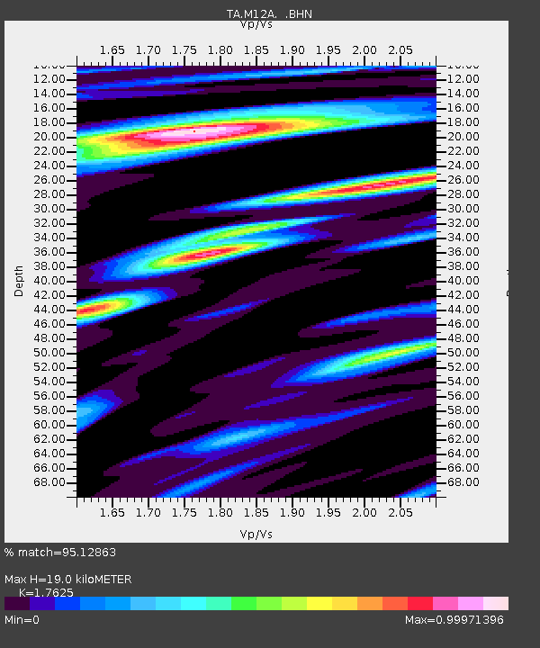
| Estimated Moho Depth: |
19.0 km |
| Estimated Crust Vp/Vs: |
1.76 |
| Assumed Crust Vp: |
6.276 km/s |
| Estimated Crust Vs: |
3.561 km/s |
| Estimated Crust Poisson's Ratio: |
0.26 |
|
| Radial Match: |
95.12863 % |
| Radial Bump: |
400 |
| Transverse Match: |
82.49296 % |
| Transverse Bump: |
400 |
| SOD ConfigId: |
2564 |
| Insert Time: |
2010-03-07 03:17:56.214 +0000 |
| GWidth: |
2.5 |
| Max Bumps: |
400 |
| Tol: |
0.001 |
|

Signal To Noise
| Channel | StoN | STA | LTA |
| TA:M12A: :BHN:20071031T03:41:55.199001Z | 4.9258513 | 7.005297E-7 | 1.4221494E-7 |
| TA:M12A: :BHE:20071031T03:41:55.199001Z | 6.6188617 | 1.3256625E-6 | 2.0028557E-7 |
| TA:M12A: :BHZ:20071031T03:41:55.199001Z | 22.53877 | 4.1953363E-6 | 1.8613865E-7 |
| Arrivals |
| Ps | 2.4 SECOND |
| PpPs | 8.2 SECOND |
| PsPs/PpSs | 11 SECOND |


