You are here: Home > Network List > TA - USArray Transportable Network (new EarthScope stations) Stations List
> Station M12A Wells, NV, USA > Earthquake Result Viewer
M12A Wells, NV, USA - Earthquake Result Viewer
| Earthquake location: |
South Of Fiji Islands |
| Earthquake latitude/longitude: |
-25.8/179.5 |
| Earthquake time(UTC): |
2007/10/16 (289) 21:05:43 GMT |
| Earthquake Depth: |
509 km |
| Earthquake Magnitude: |
6.2 MB, 6.6 MW, 6.5 MW |
| Earthquake Catalog/Contributor: |
WHDF/NEIC |
|
| Network: |
TA USArray Transportable Network (new EarthScope stations) |
| Station: |
M12A Wells, NV, USA |
| Lat/Lon: |
41.42 N/114.92 W |
| Elevation: |
1930 m |
|
| Distance: |
90.3 deg |
| Az: |
43.213 deg |
| Baz: |
235.168 deg |
| Ray Param: |
0.04150572 |
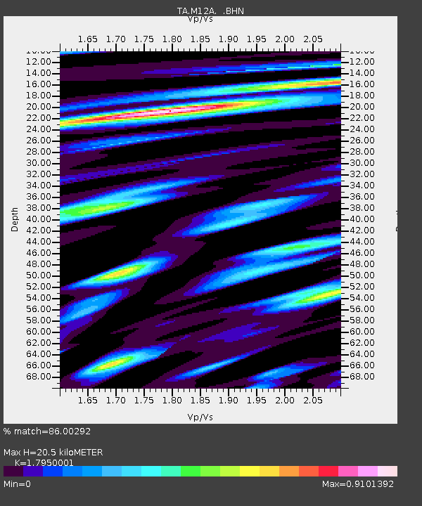
| Estimated Moho Depth: |
20.5 km |
| Estimated Crust Vp/Vs: |
1.80 |
| Assumed Crust Vp: |
6.276 km/s |
| Estimated Crust Vs: |
3.496 km/s |
| Estimated Crust Poisson's Ratio: |
0.27 |
|
| Radial Match: |
86.00292 % |
| Radial Bump: |
400 |
| Transverse Match: |
75.31211 % |
| Transverse Bump: |
400 |
| SOD ConfigId: |
2564 |
| Insert Time: |
2010-03-07 03:17:58.086 +0000 |
| GWidth: |
2.5 |
| Max Bumps: |
400 |
| Tol: |
0.001 |
|
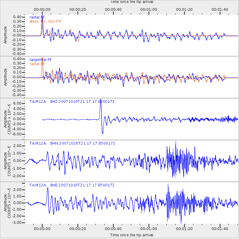
Signal To Noise
| Channel | StoN | STA | LTA |
| TA:M12A: :BHN:20071016T21:17:17.850017Z | 4.037968 | 5.5769254E-7 | 1.3811217E-7 |
| TA:M12A: :BHE:20071016T21:17:17.850017Z | 6.145068 | 9.140086E-7 | 1.4873856E-7 |
| TA:M12A: :BHZ:20071016T21:17:17.850017Z | 28.276604 | 3.1298898E-6 | 1.10688326E-7 |
| Arrivals |
| Ps | 2.6 SECOND |
| PpPs | 9.0 SECOND |
| PsPs/PpSs | 12 SECOND |


