You are here: Home > Network List > TA - USArray Transportable Network (new EarthScope stations) Stations List
> Station F24K Squaw Lake, AK, USA > Earthquake Result Viewer
F24K Squaw Lake, AK, USA - Earthquake Result Viewer
| Earthquake location: |
Mariana Islands |
| Earthquake latitude/longitude: |
16.6/146.4 |
| Earthquake time(UTC): |
2019/08/18 (230) 18:00:29 GMT |
| Earthquake Depth: |
34 km |
| Earthquake Magnitude: |
5.9 Mi |
| Earthquake Catalog/Contributor: |
NEIC PDE/pt |
|
| Network: |
TA USArray Transportable Network (new EarthScope stations) |
| Station: |
F24K Squaw Lake, AK, USA |
| Lat/Lon: |
67.52 N/147.89 W |
| Elevation: |
736 m |
|
| Distance: |
65.6 deg |
| Az: |
22.639 deg |
| Baz: |
253.706 deg |
| Ray Param: |
0.058130156 |
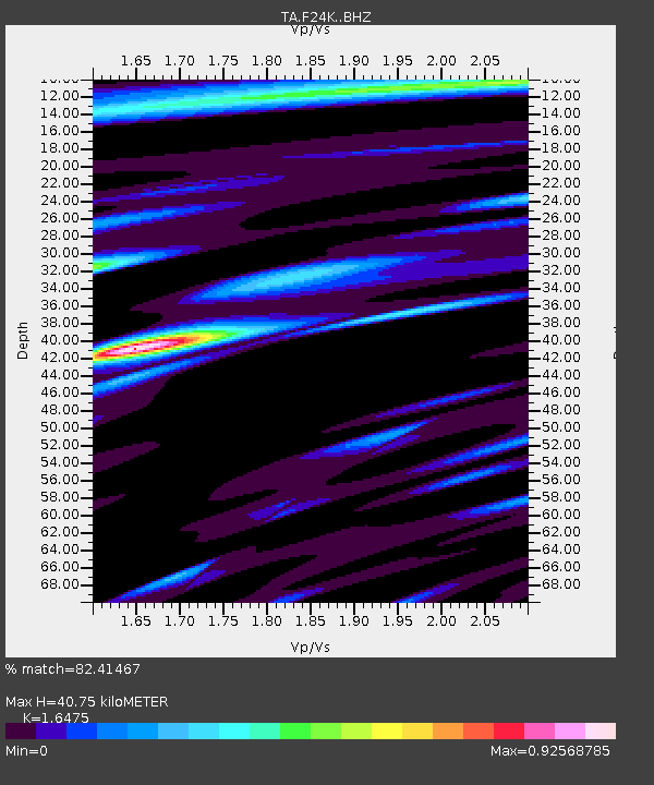
| Estimated Moho Depth: |
40.75 km |
| Estimated Crust Vp/Vs: |
1.65 |
| Assumed Crust Vp: |
6.522 km/s |
| Estimated Crust Vs: |
3.958 km/s |
| Estimated Crust Poisson's Ratio: |
0.21 |
|
| Radial Match: |
82.41467 % |
| Radial Bump: |
400 |
| Transverse Match: |
82.415764 % |
| Transverse Bump: |
400 |
| SOD ConfigId: |
19053131 |
| Insert Time: |
2019-09-01 18:11:32.614 +0000 |
| GWidth: |
2.5 |
| Max Bumps: |
400 |
| Tol: |
0.001 |
|
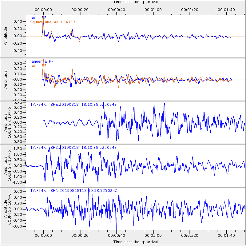
Signal To Noise
| Channel | StoN | STA | LTA |
| TA:F24K: :BHZ:20190818T18:10:38.525024Z | 15.491442 | 8.5467957E-7 | 5.5171082E-8 |
| TA:F24K: :BHN:20190818T18:10:38.525024Z | 2.9141366 | 1.5633287E-7 | 5.3646374E-8 |
| TA:F24K: :BHE:20190818T18:10:38.525024Z | 4.3171453 | 3.2216485E-7 | 7.462451E-8 |
| Arrivals |
| Ps | 4.2 SECOND |
| PpPs | 16 SECOND |
| PsPs/PpSs | 20 SECOND |


