You are here: Home > Network List > TA - USArray Transportable Network (new EarthScope stations) Stations List
> Station F26K Sheenjek River, AK, USA > Earthquake Result Viewer
F26K Sheenjek River, AK, USA - Earthquake Result Viewer

| Earthquake location: |
Mariana Islands |
| Earthquake latitude/longitude: |
16.6/146.4 |
| Earthquake time(UTC): |
2019/08/18 (230) 18:00:29 GMT |
| Earthquake Depth: |
34 km |
| Earthquake Magnitude: |
5.9 Mi |
| Earthquake Catalog/Contributor: |
NEIC PDE/pt |
|
| Network: |
TA USArray Transportable Network (new EarthScope stations) |
| Station: |
F26K Sheenjek River, AK, USA |
| Lat/Lon: |
67.69 N/144.15 W |
| Elevation: |
683 m |
|
| Distance: |
67.0 deg |
| Az: |
22.845 deg |
| Baz: |
257.245 deg |
| Ray Param: |
0.057187084 |
| Estimated Moho Depth: |
28.75 km |
| Estimated Crust Vp/Vs: |
1.84 |
| Assumed Crust Vp: |
6.522 km/s |
| Estimated Crust Vs: |
3.549 km/s |
| Estimated Crust Poisson's Ratio: |
0.29 |
|
| Radial Match: |
88.10904 % |
| Radial Bump: |
400 |
| Transverse Match: |
67.42854 % |
| Transverse Bump: |
400 |
| SOD ConfigId: |
19053131 |
| Insert Time: |
2019-09-01 18:11:32.630 +0000 |
| GWidth: |
2.5 |
| Max Bumps: |
400 |
| Tol: |
0.001 |
|
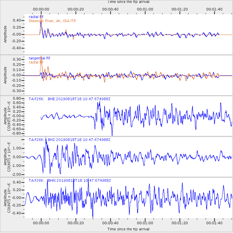
Signal To Noise
| Channel | StoN | STA | LTA |
| TA:F26K: :BHZ:20190818T18:10:47.674988Z | 13.433627 | 9.868411E-7 | 7.3460505E-8 |
| TA:F26K: :BHN:20190818T18:10:47.674988Z | 1.9986454 | 1.37669E-7 | 6.888116E-8 |
| TA:F26K: :BHE:20190818T18:10:47.674988Z | 5.428558 | 3.319849E-7 | 6.115527E-8 |
| Arrivals |
| Ps | 3.8 SECOND |
| PpPs | 12 SECOND |
| PsPs/PpSs | 16 SECOND |


